
Auction results
Loeb-Larocque Rare Maps and Books has over 27 years of expertise in old maps, atlases and illustrated books. If you are considering selling separate items or a complete collection, please do not hesitate to contact us for advice.
We purchase immediately or act as experts for Parisian auction houses like Binoche et Giquello, PIASA, Daguerre, Rossini, Kahn-Dumousset, and Libert.
Béatrice Loeb works for auction houses outside of Paris, such as Couton Veyrac in Nantes and Vichy Enchères in Vichy.
Past Auction Results
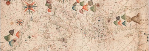
Portulan
PLACIDO CALOIRO et OLIVA [or workshop]. [Portulan de la Méditerranée]. Messine, ca. 1621 et 1665. 71,5 x 44,5 cm. Manuscript sea chart pen and ink drawn on vellum measuring 71.5 x 44.5 cm.
Elaborately decorated in the traditional style of portulan charts. In very good condition except for two sections where the vellum is missing. On the western edge, a strip about 30 cm wide has been lost and in the southeast a small section of the corner has been torn away.
Despite these losses, the actual coverage area of the chart has not been significantly impacted.
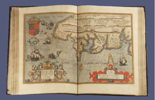
Atlas - Waghenaer
Sold for 220.000 €
WAGHENAER, Lucas Janszoon. (c. 1534 - c. 1606) (Speculum nauticum). (Leyde, Franciscus Raphelengius pour Luca Johannes Aurigarius, 1586).
Deux parties en 1 vol. in-folio : Première partie : (1) f. de titre, (2) ff., 36 pp. et 22 cartes en coloris d’époque ; Seconde partie : - (1) f. de dédicace et 23 cartes en coloris d’époque. Reliure de l'époque, veau brun, dos à nerfs orné, plats ornés d’un motif central de tapis persan repris dans les angles, tête et tr. dor. (reliure de l’éditeur).
Exemplaire de luxe de cette première édition en latin du « Spieghel der Zeevaerdt » dont les cartes ont été gravées par Baptist et Joannes van Deutecum. La traduction en latin est due à Martin Everart.
Vente Collections du Musée de la Citadelle Vauban, Belle-Île-en-Mer
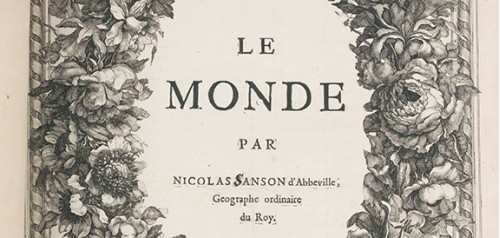
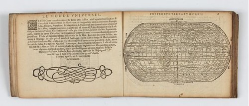
Atlas Sanson
SANSON, N. - Le Monde par Nicolas Sanson d’Abbeville, Geographe ordinaire du Roy. A Paris chez N. Langlois rue St. Jacques à la Victoire, c. 1662-1664.
Unrecorded edition by Nicolas Langlois of Nicolas Sanson’s world atlas, probably published ca. 1662-1664.
Atlas - Claes
HEYNS, Zacharie. Le Miroir du Monde, ou, Epitome du Theatre d'Abraham Ortelius. Amsterdam, Z. Heyns, 1598. Oblong 8vo (155 x 208 mm) ; ff. (1), 16-97, (1) and 80 woodcut maps. Contemporary limp vellum binding decorated with a gilt central medallion, flat spine with gilt fleurons and fillets. Gilt edges.
The first edition, published in Amsterdam in 1598, illustrated with 80 woodcut maps. Unusual Zacharias Heyns's edition, in French, of Ortelius' "Epitome".

Atlas - Neptune
DÉPÔT DES CARTES ET PLANS DE LA MARINE / SARTINE. Neptune américo-septentrional contenant les cotes, iles et bancs, les baies, ports, et mouillages, et les sondes des mers de cette-partie du monde, depuis le Groenland inclusivement, jusques et compris le golfe du Mexique. Paris, Dépôt des Cartes et Plans de la Marine, [1780].
Folio. Engraved title-page, 26 engraved maps and plans of the Atlantic seaboard on 13 full sheets and 5 half sheets. Blue paper boards.
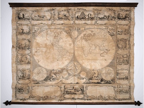
Mappemonde
CHAMBON, Gobert-Denis. Mappemonde contenant les parties connues du globe terrestre dressée suivant de nouvelles observations. Paris, Longchamps et Janvier, 1754. Wall map printed on two sheets and surrounded by borders with biblical vignettes in six sheets, laid down on linen, and mounted at the time on two wooden poles. Paper browned, with crease marks and tears but without loss of paper. 1140 x 1450 mm.
Past Auction Results
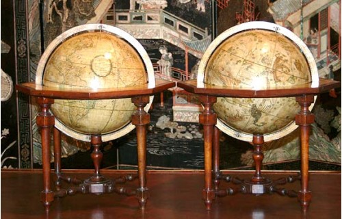
Pair of globes - G.M. Cassini
Pair of terrestrial and celestial globes by G.M. Cassini, diameter 33cm, height with stand 59cm. Rome, terrestrial dated 1790, celestial 1792.
Each globe covered by 12 printed, hand-coloured, gores, with polar calottes. The meridian circle, paper laid on wood, the horizon ring with zodiac and calendar scales on a octagonal frame supported on fruit-wood stand, the four legs united by cross-strechers carrying the centrepost.
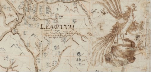
The Vichy Boym map of China
MOST PROBABLY THE 4th KNOWN EXAMPLE IN MANUSCRIPT OF ONE OF THE MOST FAMOUS MAPS OF CHINA, produced by the Polish Jesuit Michael Boym, to convey Jesuits’ knowledge of the country to Europeans.
BOYM, Michal Piotr. (1612-1659).
…mperii Mappa…num Catay Appellabatur (Map of China). Rome ?, ca. 1652-1656
Part of a larger manuscript wall map on paper produced in black and brown pen and ink. Longitudes and latitudes are drawn in red ochre. Dimensions of the map: 780 x 810 mm, total dimensions: 1100 x 1070 mm. ( 43x41 inches)
Do you want to sell
Béatrice Loeb is for more than 30 years an expert selling at auctions held by leading auction houses as Binoche & Giquello, PIASA, Ader Nordmann, Daguerre, Rossini, Nouvelle Etude, Kahn-Dumousset and Libert at Drouot or auctionhouses outside Paris.
Member of SFEP (Syndicat Français des Experts Professionnels en Œuvres d'Art et Objets de Collection). Founded in 1945, the SFEP is the oldest organization representing professional appraisers in fine art and antiquities in France.
Our auction catalog descriptions are prepared in accordance with the guidelines set by the SFEP.
We provide a free appraisal if you are considering selling one of your maps, atlases or books. Such auction estimates are not for valuation purposes and are subject to revision on inspection of the object.
Béatrice Loeb (expert)
31 rue de Tolbiac, 75013 Paris, France
By appointment only
Tel.: +33 (0)1 84 88 45 86 / +33 (0)1 44.24.85.80
cell +33 (0)6.11.80.33.75
Email : info@loeb-larocque.com
contact form >>>>