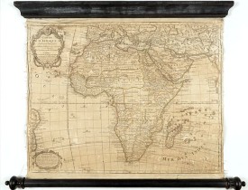
De L'ISLE/ BUACHE,Ph. - Carte D'Afrique Dressée pour l'usage du Roy. Par Guillaume Delisle, Premier Géographe de Sa Majesté, de l'Académie Royale des Sciences…
 cliquez sur l'image pour l'agrandir

De L'ISLE/ BUACHE,Ph. - Carte D'Afrique Dressée pour l'usage du Roy. Par Guillaume Delisle, Premier Géographe de Sa Majesté, de l'Académie Royale des Sciences…
Date: Paris, 1781
Format: 440 x 675mm.
Color: Limites en col. ancien.
Condition: Dark impression. Mounted on canvas and with original wooden rollers. Good condition.
Description
Curious late issue of De L'Isle's map of the African continent from 1722 map "Corrigée et Augmentée en 1781". - The decorative map shows the continent Africa with Arabia and the east coast of Brazil. - The top left title cartouche has the publisher's address. - At the bottom left "Advertisement" cartouche.
Philippe Buache was one of the most active proponents of the so-called School of theoretical cartography active in mid-18th century France.
Philippe Buache was one of the most active proponents of the so-called School of theoretical cartography active in mid-18th century France.
1 250€
- N° Reference: 49078
3 500€

![TASSIN, N. - [Set of 14 title pages] Les plans et profils de toutes les principales villes et lieux considerables de France . . . TASSIN, N. - [Set of 14 title pages] Les plans et profils de toutes les principales villes et lieux considerables de France . . .](https://www.loeb-larocque.com/eshop/image/cache/catalog/image/new_upload/48028-275x210h.jpg)
