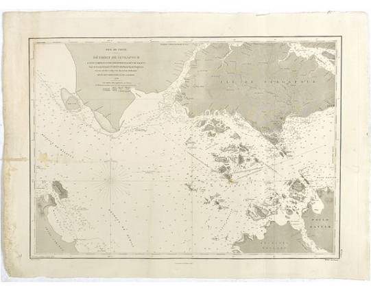
HYDROGRAPHIC OFFICE OF THE ADMIRALTY. - Mer de Chine - Detroit De Singapour Partie Comprise Entre Singaour et Le Dett. De Malacca d'apres les travaux du Commr. J.W. Reed de la Marine Royale d'Angleterr, executes de 1865 a 1869 et les documents Hollandais
 cliquez sur l'image pour l'agrandir

HYDROGRAPHIC OFFICE OF THE ADMIRALTY. - Mer de Chine - Detroit De Singapour Partie Comprise Entre Singaour et Le Dett. De Malacca d'apres les travaux du Commr. J.W. Reed de la Marine Royale d'Angleterr, executes de 1865 a 1869 et les documents Hollandais
Date: London, 1873
Format: 443 x 620 mm.
Color: Noir et blanc.
Condition: Some marginal discolouration. Generally in very good condition.
Description
A detailed chart of Singapore Strait, drawn from an English Chart by J.W. Reed, who surveyed Singapore and environs between 1865 and 1869, aboard the H.M.S. Rifleman.
The chart is one of the earliest maps to focus in significant detail on the region, following only 20 years after John Turnbull Thomson and Samuel Congalton's original survey work.
The chart is quite rare and apparently only a 1873 or 1877 edition of the map is known.
The Dépôt de la Marine, known more formally as the Dépôt des cartes et plans de la Marine, was the central charting institution of France. The centralization of hydrography in France began in earnest when Jean-Baptiste Colbert became First Minister of France in 1661. Under his watch, the first Royal School of Hydrography began operating, as did the first survey of France’s coasts (1670-1689). In 1680, Colbert consolidated various collections of charts and memoirs into a single assemblage, forming the core of sources for what would become the Dépôt.
The Dépôt continued to operate until 1886, when it became the Naval Hydrographic Service.
2 500€
- N° Reference: 42885
Etiquettes :
HYDROGRAPHIC OFFICE OF THE ADMIRALTY. - Mer de Chine - Detroit De Singapour Partie Comprise Entre Singaour et Le Dett. De Malacca d'apres les travaux du Commr. J.W. Reed de la Marine Royale d'Angleterr
, executes de 1865 a 1869 et les documents Hollandais
, Malaisie - Singapour
2 500€
4 000€
325€


![BRAUN,G. / HOGENBERG, F. - Prospectus amoeniss. vallis Oeniponticae una cum antro in altissima et praeruptissima rupe Imp. Maximiliani primi. [on sheet with:] Schlosberg. die Clause in Alpibus Tirolensibus. [and:] Monument. occursus Imp. Caroli V. et Fer BRAUN,G. / HOGENBERG, F. - Prospectus amoeniss. vallis Oeniponticae una cum antro in altissima et praeruptissima rupe Imp. Maximiliani primi. [on sheet with:] Schlosberg. die Clause in Alpibus Tirolensibus. [and:] Monument. occursus Imp. Caroli V. et Fer](https://www.loeb-larocque.com/eshop/image/cache/catalog/image/new_upload/47903-275x210w.jpg)