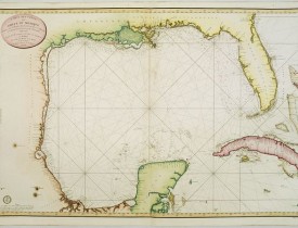
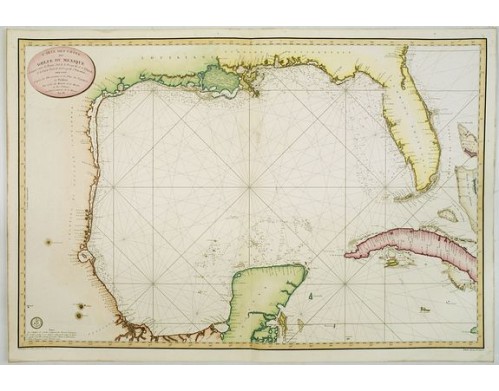
DÉPÔT GÉNÉRAL DE LA MARINE. - Carte des cotes du Golfe du Mexique..
Date: Paris, 1800
Format: 598 x 893mm.
Color: Col.
Condition: Several wormholes filled in, hardly notable. Overall in very good condition.
Description
Detailed and important early chart of the Gulf Coast and Florida and dated 1800.
First French edition of "the first printed [map] to show and name Galveston Bay" and "the first large-scale printed chart of Texas and the Gulf Coast based on actual soundings and explorations" (Martin & Martin); the first printing of this handsome chart appeared in Madrid in 1799; the present French version quickly followed, appearing in J. N. Bellin et al., "Hydrographie Françoise"; all versions of this chart are exceedingly rare. Lowery 721n. Phillips, Atlases 590.
The chart was issued one year after the Spanish Carta Esferica and draws extensively from this map.
The chart is based in large part on the landmark survey of the coast commissioned by Bernardo de Galvez and conducted by Jose de Evia. The most significant milestone of the survey was the discovery of Galveston Bay in 1785, which had never before appeared on a printed map. Baie de Calvesion (Galveston) is shown on the present map exactly as laid down in the manuscript maps from Evia's Survey.
The coastline configuration in established the prototype for the mapping of Texas and the U.S. Gulf Coast, which would dominate printed maps for the next 2 decades. The map remained as one of the most significant charts of the region for several decades. Both Humboldt and Arrowsmith copied the information outlined in this map for their important maps.
For the first time, the Texas coast was mapped from an actual survey, and the chart was the first in print to show and name Galveston Bay.... Later map makers who made use of the chart in one fashion or another included Alexander von Humboldt and John Melish, and it was not until the publication of Austin's map in 1830 that the configuration introduced on the Carta esférica was superseded. Both the Spanish and French editions are very scarce. Streeter located just eight copies of the [various issues] of the Spanish edition and four copies of the French among seventy-six important institutional collections that he surveyed. Streeter locates no copies of the French edition in Texas.
On the map it is noted Grave par E. Collin, et Ecrit par Besançon, Etienne Collin is also noted as being an engraver for 'Depot de la Marine'. It is probable that Collin engraved the map after originals by Besançon.
First French edition of "the first printed [map] to show and name Galveston Bay" and "the first large-scale printed chart of Texas and the Gulf Coast based on actual soundings and explorations" (Martin & Martin); the first printing of this handsome chart appeared in Madrid in 1799; the present French version quickly followed, appearing in J. N. Bellin et al., "Hydrographie Françoise"; all versions of this chart are exceedingly rare. Lowery 721n. Phillips, Atlases 590.
The chart was issued one year after the Spanish Carta Esferica and draws extensively from this map.
This French edition is virtually identical to the Spanish of the preceding year, but is more finely engraved. The 1799 Carta Esferica, was the first large-scale printed chart of the Texas Coast based upon actual soundings and explorations.
The coastline configuration in established the prototype for the mapping of Texas and the U.S. Gulf Coast, which would dominate printed maps for the next 2 decades. The map remained as one of the most significant charts of the region for several decades. Both Humboldt and Arrowsmith copied the information outlined in this map for their important maps.
For the first time, the Texas coast was mapped from an actual survey, and the chart was the first in print to show and name Galveston Bay.... Later map makers who made use of the chart in one fashion or another included Alexander von Humboldt and John Melish, and it was not until the publication of Austin's map in 1830 that the configuration introduced on the Carta esférica was superseded. Both the Spanish and French editions are very scarce. Streeter located just eight copies of the [various issues] of the Spanish edition and four copies of the French among seventy-six important institutional collections that he surveyed. Streeter locates no copies of the French edition in Texas.
On the map it is noted Grave par E. Collin, et Ecrit par Besançon, Etienne Collin is also noted as being an engraver for 'Depot de la Marine'. It is probable that Collin engraved the map after originals by Besançon.
Streeter 1030 (locating four copies: Library of Congress, Harvard, New York Public Library, and the British Museum): "The [French edition] seems almost identical with the Depósito Hidrográfico chart of 1799 [Streeter 1029] as far as the Texas coastline and rivers are concerned. On this chart Passe del Caballo is shown twice, the name for the lower pass, perhaps an error, being new on this chart." Streeter in the introduction to the second part of his bibliography of Texas (p. 329) designates the 1799 Spanish version of this map (three copies located) as one of the six maps especially desirable for a Texas collection, commenting that in the final years of the eighteenth century "even the coastline of Texas was little known and its delineation by...a chart of the Depósito Hidrográfico de Marina of Spain entitled Carta esférica que comprende las costas del Seno Mexicano...represents a real advance. It is the first of two or three early maps showing the Texas coast line and the lower courses of its rivers.
This Carta esférica was one of the authorities used by Humboldt in constructing his highly acclaimed Carte Générale du Royaume de la Nouvelle Espagne.
First state (1800-1803): Year in title stated as "An IX". Depôt Général de la Marine seal with "R.F."
Second state (1804-1815): As first state, but with "E.F." in the Depôt Général de la Marine seal.
Third state (1815-1830): Year in title stated as "1800". Depôt Général de la Marine seal with fleurs-de-lis.
This Carta esférica was one of the authorities used by Humboldt in constructing his highly acclaimed Carte Générale du Royaume de la Nouvelle Espagne.
First state (1800-1803): Year in title stated as "An IX". Depôt Général de la Marine seal with "R.F."
Second state (1804-1815): As first state, but with "E.F." in the Depôt Général de la Marine seal.
Third state (1815-1830): Year in title stated as "1800". Depôt Général de la Marine seal with fleurs-de-lis.
2 000€
- N° Reference: 25159
Some of the most asked FAQ by our clients
Librairie Loeb-Larocque specializes in maps, atlases, and travel books from the 16th to 19th centuries.
The Librairie was founded in 1958 by Louis Loeb-Larocque. Originally, he arrived in France from Germany shortly after World War II. He started an antiquarian map and book shop in Paris, specializing in early maps, atlases, travel books, and prints. The shop was located at Rue Le Peletier until 1996, and was frequently visited by collectors and fellow dealers from all parts of the world.
At present, the office is located at 31 rue de Tolbiac in Paris in the lively 13th district, a 5-minute walk from the Bibliothéque Nationale de France (Metro Line 14)
Visitors are welcome to our shop by appointment, Monday through Friday.
The Librairie was founded in 1958 by Louis Loeb-Larocque. Originally, he arrived in France from Germany shortly after World War II. He started an antiquarian map and book shop in Paris, specializing in early maps, atlases, travel books, and prints. The shop was located at Rue Le Peletier until 1996, and was frequently visited by collectors and fellow dealers from all parts of the world.
At present, the office is located at 31 rue de Tolbiac in Paris in the lively 13th district, a 5-minute walk from the Bibliothéque Nationale de France (Metro Line 14)
Visitors are welcome to our shop by appointment, Monday through Friday.
Librairie Loeb-Larocque sells authentic maps, prints, atlases, and rare books. We guarantee the authenticity and condition of each lot listed in our catalogs.
Browse the catalog now >>>
We supply a certificate for each item sold. Librairie Loeb-Larocque guarantees the authenticity and condition of each lot described in our catalogs.
The warranty has no time limit. Defects in lots offered for sale have been carefully noted.
Sauf indication contraire, toutes les cartes sont des gravures sur cuivre ou des eaux-fortes.
· Col. ancien/d’époque signifie que le lot a été colorié lors (ou aux environs) de sa publication,
- col. signifie que le lot a été colorié récemment.
Browse the catalog now >>>
· Col. ancien/d’époque signifie que le lot a été colorié lors (ou aux environs) de sa publication,
- col. signifie que le lot a été colorié récemment.
Browse the catalog now >>>
The value of any rare book, atlas, globe, print, or map is affected by many factors: its rarity, condition, binding, provenance, and the significance of any inscriptions it may contain.
Béatrice Loeb-Larcque, an expert and member of the Syndicat Français des Experts Professionnels en Œuvres d'Art et Objets de Collection, provides a free appraisal if you are considering selling.
We provide auction estimates based on photographs sent via the Internet. These estimates are not for valuation purposes and are subject to revision upon inspection of the object.
It is impossible to provide verbal estimates by telephone, nor can we respond to requests sent without a photo.
There is no easy answer to this question. Some books or maps have, without question, appreciated considerably in value over the years.
Others have remained steadily desirable without seeing a significant rise in price, and still others can be purchased for little money but give great personal satisfaction.
Librairie Loeb-Larocque, with 60 years of experience in the rare map and book trade, can help you decide what kind of collection you would like to build.
Others have remained steadily desirable without seeing a significant rise in price, and still others can be purchased for little money but give great personal satisfaction.
Librairie Loeb-Larocque, with 60 years of experience in the rare map and book trade, can help you decide what kind of collection you would like to build.
Nous recherchons en permanence pour nos clients et notre stock des ouvrages et cartes rares dans nos domaines de spécialités : atlas, cartes géographiques, voyages et livres illustrés.
Si vous avez des ouvrages et des cartes à vendre dans l’un de ces domaines, ou bien une bibliothèque complète, veuillez consulter la liste ci-dessous, qui vous donnera un aperçu de ce que nous recherchons.
DO A FREE APPRAISAL >>>
Si vous avez des ouvrages et des cartes à vendre dans l’un de ces domaines, ou bien une bibliothèque complète, veuillez consulter la liste ci-dessous, qui vous donnera un aperçu de ce que nous recherchons.
DO A FREE APPRAISAL >>>
En vertu des dispositions des articles L.121-20-12 et suivants du Code de la Consommation, le client dispose d'un délai de quatorze jours francs pour exercer son droit de rétractation sans avoir à justifier de motifs, à compter de la date de réception de sa commande. Les frais d'envoi et de retour seront à la charge du client. Les produits, accompagnés d'un RIB du client, devront être retournés par la Poste, dans un parfait état et dans leur emballage d'origine à l'adresse suivante : 31 rue de Tolbiac, 75013.
Les remboursements s'effectueront par crédit de la carte bancaire du client, dans un délai de 3 jours. En cas de retour d'un produit endommagé, incomplet ou abîmé, celui-ci ne sera ni échangé ni remboursé.
Browse the catalog now >>>
Les remboursements s'effectueront par crédit de la carte bancaire du client, dans un délai de 3 jours. En cas de retour d'un produit endommagé, incomplet ou abîmé, celui-ci ne sera ni échangé ni remboursé.
Browse the catalog now >>>
Les commandes peuvent être livrées n'importe où dans le monde. Les commandes seront livrées par DHL, par Colissimo ou un autre opérateur.
La livraison des produits ne sera effective qu'après encaissement du montant total de la commande. Les produits seront livrés à l'adresse indiquée par le client, au moment du passage de sa commande.
- Livraison France métropolitaine : Les commandes seront livrées en DHL pour 25 euros, ou Colissimo pour 20,00 Euros. Le délai de livraison moyen est de 1-3 jours ouvrés.
- Livraison Europe : Les commandes seront livrées en DHL pour 25,00 Euros. Le délai de livraison moyen est de 2-4 jours ouvrés.
- Livraison hors Europe : Les commandes seront livrées par DHL pour 25,00 Euros. Le délai de livraison moyen est de 2 - 5 jours ouvrés. Le délai est indiqué seulement à titre indicatif et ne constitue pas un engagement ferme de notre part.
Browse the catalog now >>>
La livraison des produits ne sera effective qu'après encaissement du montant total de la commande. Les produits seront livrés à l'adresse indiquée par le client, au moment du passage de sa commande.
- Livraison France métropolitaine : Les commandes seront livrées en DHL pour 25 euros, ou Colissimo pour 20,00 Euros. Le délai de livraison moyen est de 1-3 jours ouvrés.
- Livraison Europe : Les commandes seront livrées en DHL pour 25,00 Euros. Le délai de livraison moyen est de 2-4 jours ouvrés.
- Livraison hors Europe : Les commandes seront livrées par DHL pour 25,00 Euros. Le délai de livraison moyen est de 2 - 5 jours ouvrés. Le délai est indiqué seulement à titre indicatif et ne constitue pas un engagement ferme de notre part.
Browse the catalog now >>>
Nos locaux sont situés au 31 rue de Tolbiac, dans le 13ème arrondissement de Paris, à 300 m du métro Bibliothèque François Mitterrand (ligne 14).
Nous recevons exclusivement sur rendez-vous du lundi au vendredi de 9h à 19h..
CONTACT US
Nous recevons exclusivement sur rendez-vous du lundi au vendredi de 9h à 19h..
CONTACT US