Menu
Menu
Your Cart

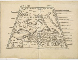
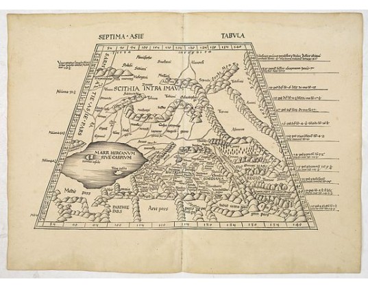
PTOLOMY, C. / WALDSEEMÜLLER, M. - Septima Asie Tabula (Central Asia.)
PTOLOMY, C. / WALDSEEMÜLLER, M. -  Septima Asie Tabula  (Central Asia.)
PTOLOMY, C. / WALDSEEMÜLLER, M. - Septima Asie Tabula (Central Asia.)
Date: Strasburg, 1513
Format: 340 x 545mm.
Color: Noir et blanc.
Condition: Good impression. Some minor discolouration and water staining in outer margin. Paper slightly age toned. Some old backing along center fold due to some small splits. Printed on heavy paper.

Description

A woodblock-printed large-format Ptolemaic map showing the region east of the Caspian Sea is labeled SOGDIANA. Sogdia or Sogdiana was an ancient Iranian civilization between the Amu Darya and the Syr Darya, in present-day Uzbekistan, Turkmenistan, Tajikistan, Kazakhstan, and Kyrgyzstan. It is one of the earliest obtainable maps of the region.

Central Asia and Turkistan, with a horizontal delineation of the Caspian Sea. Turkistan, the mystical land of Samarkand, was the farthest known reaches of the world, as known to Ptolemy. The map shows the mountainous area of Pamir and Imaus in the east, with the trade routes through the tribal areas of Bactria and Sogdiana with Scythia to the north and the Caspian Sea to the west.
“This complex territory constituted the Silk Road, a network of overland trails from China to the Mediterranean. Embracing parts of today’s Iran, China, India and the central Asian countries of the former Soviet Union, mysteries about the region’s geography and ethnology persisted until the end of the nineteenth century”. See: Nebenzahl, Mapping the Silk Road.


The Sogdian city-states, although never politically united, were centered on the city of Samarkand.
Sogdians also lived in Imperial China and rose to prominence in the military and government of the Chinese Tang dynasty (618–907 AD). Sogdian merchants and diplomats traveled as far west as the Byzantine Empire. They played an essential part as middlemen in the Silk Road trade route.

 
From the 1513 edition of Waldseemüller's Geographia.

This Ptolemaic map comes from the first so-called 'Modern Atlas' by the most famous of all early sixteenth-century cosmographers Martin Waldseemüller.
The Atlas is titled GEOGRAPHIE OPUS NOVISSIMA TRADUCTIONE E GRECORUM ARCHETYPIS and was published by Johannes Schott in Strasburg in 1513. It is one of the most important editions of Ptolemy's Atlases.

5 000€
  • N° Reference: 33770

Some of the most asked FAQ by our clients

Librairie Loeb-Larocque specializes in maps, atlases, and travel books from the 16th to 19th centuries.

The Librairie was founded in 1958 by Louis Loeb-Larocque. Originally, he arrived in France from Germany shortly after World War II. He started an antiquarian map and book shop in Paris, specializing in early maps, atlases, travel books, and prints. The shop was located at Rue Le Peletier until 1996, and was frequently visited by collectors and fellow dealers from all parts of the world.

At present, the office is located at 31 rue de Tolbiac in Paris in the lively 13th district, a 5-minute walk from the Bibliothéque Nationale de France (Metro Line 14)

Visitors are welcome to our shop by appointment, Monday through Friday.
Librairie Loeb-Larocque sells authentic maps, prints, atlases, and rare books. We guarantee the authenticity and condition of each lot listed in our catalogs.
Browse the catalog now >>>
We supply a certificate for each item sold. Librairie Loeb-Larocque guarantees the authenticity and condition of each lot described in our catalogs.
The warranty has no time limit. Defects in lots offered for sale have been carefully noted.
The value of any rare book, atlas, globe, print, or map is affected by many factors: its rarity, condition, binding, provenance, and the significance of any inscriptions it may contain. Béatrice Loeb-Larcque, an expert and member of the Syndicat Français des Experts Professionnels en Œuvres d'Art et Objets de Collection, provides a free appraisal if you are considering selling. We provide auction estimates based on photographs sent via the Internet. These estimates are not for valuation purposes and are subject to revision upon inspection of the object. It is impossible to provide verbal estimates by telephone, nor can we respond to requests sent without a photo.
There is no easy answer to this question. Some books or maps have, without question, appreciated considerably in value over the years.
Others have remained steadily desirable without seeing a significant rise in price, and still others can be purchased for little money but give great personal satisfaction.
Librairie Loeb-Larocque, with 60 years of experience in the rare map and book trade, can help you decide what kind of collection you would like to build.
Nous recherchons en permanence pour nos clients et notre stock des ouvrages et cartes rares dans nos domaines de spécialités : atlas, cartes géographiques, voyages et livres illustrés.
Si vous avez des ouvrages et des cartes à vendre dans l’un de ces domaines, ou bien une bibliothèque complète, veuillez consulter la liste ci-dessous, qui vous donnera un aperçu de ce que nous recherchons.

DO A FREE APPRAISAL >>>
Nos locaux sont situés au 31 rue de Tolbiac, dans le 13ème arrondissement de Paris, à 300 m du métro Bibliothèque François Mitterrand (ligne 14).
Nous recevons exclusivement sur rendez-vous du lundi au vendredi de 9h à 19h..
CONTACT US