Menu
Menu
Your Cart

SCHEDEL, H. - (EUROPE).
SCHEDEL, H. -  (EUROPE).
SCHEDEL, H. - (EUROPE).
Date: Nuremberg, 1493
Format: 392 x 575mm.
Color: Col.
Condition: Skillfully restored at the bottom corners. On the right side some paper thinness. Small area ca. 1-3 mm part on the left side ( eg.: letter "B" in the world BRITANICA and some part on the lover right corner are replaced or redrawn in a professional way. Overall nice example.

Description

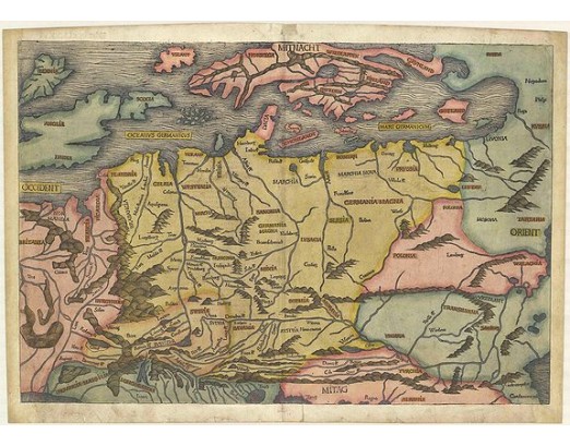
Map of Northern Europe and centered on Poland. First issue, with Latin text colophon and date on verso. The map is deemed to be the first printed map of Germany, even if it shows a larger area. W. B. Grinsberg characterized this map as the first modern map of northern and central Europe. The map ranges from the British Isles to Constantinople.
The designer has been identified as Hieronymus Münzer (1437-1508), who trained as a physician.

Nordenskold credits the map of the north in the Zamoyski codes as the prototype for this map. The source for the central European portion is a manuscript map of 1460 of Germany by Cardinal Nicolas Cusanus (also Nicholas of Cusa), printed posthumously at Eichstätt in 1491.

Page from the richest illustrated Incunable, the famous: Nuremberg Chronicle, published the year that Columbus returned to Europe after discovering America. In May of 1493 appeared in the Latin language one of the earliest voluminous books, fully illustrated with 1809 woodcuts printed from 645 woodblocks.
The woodblock cutters were Michael Wolgemut, the well-known teacher of Albrecht Dürer, and his stepson Wilhelm Pleydenwurff. Wohlgemut was Albrecht Dürer's tutor between 1486-90 and recent scholarship has shown, Albrecht Dürer may also have collaborated, since some of the cuts bear a remarkably close resemblance to the Apocalypse illustrations.
The printing was carried out under the supervision of the great scholar-printer Anton Koberger, whose printing were famous throughout Europe.
5 000€
  • Voir les autre produits par: SCHEDEL, H.
  • N° Reference: 41515

Some of the most asked FAQ by our clients

Librairie Loeb-Larocque specializes in maps, atlases, and travel books from the 16th to 19th centuries.

The Librairie was founded in 1958 by Louis Loeb-Larocque. Originally, he arrived in France from Germany shortly after World War II. He started an antiquarian map and book shop in Paris, specializing in early maps, atlases, travel books, and prints. The shop was located at Rue Le Peletier until 1996, and was frequently visited by collectors and fellow dealers from all parts of the world.

At present, the office is located at 31 rue de Tolbiac in Paris in the lively 13th district, a 5-minute walk from the Bibliothéque Nationale de France (Metro Line 14)

Visitors are welcome to our shop by appointment, Monday through Friday.
Librairie Loeb-Larocque sells authentic maps, prints, atlases, and rare books. We guarantee the authenticity and condition of each lot listed in our catalogs.
Browse the catalog now >>>
We supply a certificate for each item sold. Librairie Loeb-Larocque guarantees the authenticity and condition of each lot described in our catalogs.
The warranty has no time limit. Defects in lots offered for sale have been carefully noted.
The value of any rare book, atlas, globe, print, or map is affected by many factors: its rarity, condition, binding, provenance, and the significance of any inscriptions it may contain. Béatrice Loeb-Larcque, an expert and member of the Syndicat Français des Experts Professionnels en Œuvres d'Art et Objets de Collection, provides a free appraisal if you are considering selling. We provide auction estimates based on photographs sent via the Internet. These estimates are not for valuation purposes and are subject to revision upon inspection of the object. It is impossible to provide verbal estimates by telephone, nor can we respond to requests sent without a photo.
There is no easy answer to this question. Some books or maps have, without question, appreciated considerably in value over the years.
Others have remained steadily desirable without seeing a significant rise in price, and still others can be purchased for little money but give great personal satisfaction.
Librairie Loeb-Larocque, with 60 years of experience in the rare map and book trade, can help you decide what kind of collection you would like to build.
Nous recherchons en permanence pour nos clients et notre stock des ouvrages et cartes rares dans nos domaines de spécialités : atlas, cartes géographiques, voyages et livres illustrés.
Si vous avez des ouvrages et des cartes à vendre dans l’un de ces domaines, ou bien une bibliothèque complète, veuillez consulter la liste ci-dessous, qui vous donnera un aperçu de ce que nous recherchons.

DO A FREE APPRAISAL >>>
Nos locaux sont situés au 31 rue de Tolbiac, dans le 13ème arrondissement de Paris, à 300 m du métro Bibliothèque François Mitterrand (ligne 14).
Nous recevons exclusivement sur rendez-vous du lundi au vendredi de 9h à 19h..
CONTACT US