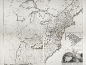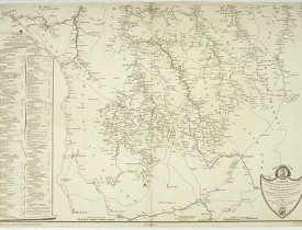
TARDIEU, P.A.F. - United States of North America. Carte des Etats-Unis de l'Amerique Septentrionale / copiée et gravée sur celle d'Arrowsmith, corrigée et considérablement augmentée... par P. F. Tardieu...
Date: Paris: An XI - 1802
Format: 1070 x 800mm.
Color: Noir et blanc.
Condition: Four map sheets, together measuring 1070 x 800mm.
Description
FIRST EDITION. An impressive wall map here in 4 unjoined sheets and large margins. RARE in these untouched, full sheets. Recorded examples are usually offered as folding case maps, including large vignettes of Niagara Falls and a plan of Washington, D.C.
Tardieu's map is a direct copy of Arrowsmith's "Map of the United States" except for certain parts (mentioned by Tardieu in his "Note" above the title) that Tardieu has altered and improved based on other sources. The map shows the eastern seaboard and extends westward to where the Missouri River crosses 97o lat.
It shows the United States and Canada.
Using Arrowsmith's map as a template, Tardieu creates a new map that reflects this Paris engraver's finer engraving skills. Over the next 18 years, Tardieu regularly updated and improved his map, often ahead of Arrowsmith, who also periodically updated his 4-sheet map for the next several decades.
Adorned with a cartouche highlighting Niagara Falls, a new American icon, it defines the nation’s boundaries and depicts Vermont, Kentucky, and Tennessee.
An inset shows Pierre L’Enfant’s plan for the nation’s capital in Washington, DC. Inspired by Baroque city designs, the plan features broad diagonal avenues imposed on a grid street system, reflecting the city’s proposal to function as a ceremonial seat of government.
Scale [ca. 1:1,860,000].
Primarily based on the work of Aaron Arrowsmith, who first published his monumental map of North America in 1796, the current map shows the United States at a time of great transition, just before the acquisition of the Louisiana Territory (1803) and before the extent of the western discoveries of Lewis and Clark during their exploring expedition of 1804, 1805, 1806, and those of Zebulon Pike of 1806 and 1807.
Remarkably fine engraving, as is characteristic of Tardieu's maps.
The map is known in 6 states:
State 1: 1802 (dated)
State 2: 1808 (adding Michigan Territory, Ohio, Vermont, Kentucky & Tennessee).
State 3: 1812 (dated) Mississippi Territory, Indiana Territory, and West Florida are shown; Louisiana does not yet appear as a state, and there is a massive area called Indiana below Lake Michigan, with an unnamed Territory to the west.
State 4: (circa 1816), adds the Illinois Territory and a massive Northwest Territory.
State 5: (circa 1818), Alabama Territory appears for the first time; the roads in Illinois Territory and Indiana Territory have been changed, and East Florida and West Florida are no longer named. State 6: 1820. Adds a set of half-sheets at the bottom of the map, extending the map's coverage to include all of Florida.
Please note that the main illustration is a compilation. The four sheets are in their original unjoined state with large margins. Very rare in this condition.
- N° Reference: 45853
0€
Questions fréquemment posées par nos clients
Librairie Loeb-Larocque specializes in maps, atlases, and travel books from the 16th to 19th centuries.
The Librairie was founded in 1958 by Louis Loeb-Larocque. Originally, he arrived in France from Germany shortly after World War II. He started an antiquarian map and book shop in Paris, specializing in early maps, atlases, travel books, and prints. The shop was located at Rue Le Peletier until 1996, and was frequently visited by collectors and fellow dealers from all parts of the world.
At present, the office is located at 31 rue de Tolbiac in Paris in the lively 13th district, a 5-minute walk from the Bibliothéque Nationale de France (Metro Line 14)
Visitors are welcome to our shop by appointment, Monday through Friday.
Librairie Loeb-Larocque sells authentic maps, prints, atlases, and rare books. We guarantee the authenticity and condition of each lot listed in our catalogs.
Browse the catalog now >>>
We supply a certificate for each item sold. Librairie Loeb-Larocque guarantees the authenticity and condition of each lot described in our catalogs.
The warranty has no time limit. Defects in lots offered for sale have been carefully noted.
Sauf indication contraire, toutes les cartes sont des gravures sur cuivre ou des eaux-fortes.
· Col. ancien/d’époque signifie que le lot a été colorié lors (ou aux environs) de sa publication,
- col. signifie que le lot a été colorié récemment.
Browse the catalog now >>>
· Col. ancien/d’époque signifie que le lot a été colorié lors (ou aux environs) de sa publication,
- col. signifie que le lot a été colorié récemment.
Browse the catalog now >>>
La valeur d’un livre rare, d’un atlas, d’un globe, d’une gravure ou d’une carte dépend de nombreux facteurs : sa rareté, son état de conservation, sa reliure, sa provenance et l’intérêt des éventuelles annotations ou inscriptions qu’il comporte.
Béatrice Loeb-Larcque, experte membre du Syndicat Français des Experts Professionnels en Œuvres d’Art et Objets de Collection, réalise des expertises dans le cadre de ventes publiques ou de successions.
Nous proposons des estimations de vente aux enchères à partir de photographies envoyées par Internet. Ces estimations n’ont pas valeur d’expertise à des fins d’évaluation et sont susceptibles d’être révisées après examen de l’objet.
Il nous est impossible de donner des estimations verbales par téléphone, et nous ne pouvons pas répondre aux demandes envoyées sans photographie.
Il n’existe pas de réponse simple à cette question. Certains livres ou cartes ont, sans conteste, pris une valeur considérable au fil des années.
D’autres restent régulièrement recherchés sans connaître de hausse de prix significative, et d’autres encore peuvent être acquis pour peu d’argent tout en procurant une grande satisfaction personnelle.
La Librairie Loeb-Larocque, forte de 60 ans d’expérience dans le commerce des cartes et livres anciens, peut vous aider à définir le type de collection que vous souhaitez constituer.
Nous recherchons en permanence pour nos clients et notre stock des ouvrages et cartes rares dans nos domaines de spécialités : atlas, cartes géographiques, voyages et livres illustrés.
Si vous avez des ouvrages et des cartes à vendre dans l’un de ces domaines, ou bien une bibliothèque complète, veuillez consulter la liste ci-dessous, qui vous donnera un aperçu de ce que nous recherchons.
DO A FREE APPRAISAL >>>
Si vous avez des ouvrages et des cartes à vendre dans l’un de ces domaines, ou bien une bibliothèque complète, veuillez consulter la liste ci-dessous, qui vous donnera un aperçu de ce que nous recherchons.
DO A FREE APPRAISAL >>>
En vertu des dispositions des articles L.121-20-12 et suivants du Code de la Consommation, le client dispose d'un délai de quatorze jours francs pour exercer son droit de rétractation sans avoir à justifier de motifs, à compter de la date de réception de sa commande. Les frais d'envoi et de retour seront à la charge du client. Les produits, accompagnés d'un RIB du client, devront être retournés par la Poste, dans un parfait état et dans leur emballage d'origine à l'adresse suivante : 31 rue de Tolbiac, 75013.
Les remboursements s'effectueront par crédit de la carte bancaire du client, dans un délai de 3 jours. En cas de retour d'un produit endommagé, incomplet ou abîmé, celui-ci ne sera ni échangé ni remboursé.
Browse the catalog now >>>
Les remboursements s'effectueront par crédit de la carte bancaire du client, dans un délai de 3 jours. En cas de retour d'un produit endommagé, incomplet ou abîmé, celui-ci ne sera ni échangé ni remboursé.
Browse the catalog now >>>
Les commandes peuvent être livrées n'importe où dans le monde. Les commandes seront livrées par DHL, par Colissimo ou un autre opérateur.
La livraison des produits ne sera effectuée qu'après encaissement du montant total de la commande. Les produits seront livrés à l'adresse indiquée par le client lors du passage de sa commande.
- Livraison France métropolitaine : Les commandes seront livrées par DHL pour 25 euros, ou par Colissimo pour 20,00 euros. Le délai de livraison moyen est de 1 à 3 jours ouvrés.
- Livraison en Europe : Les commandes seront livrées par DHL pour 25,00 euros. Le délai de livraison moyen est de 2 à 4 jours ouvrés.
- Livraison hors Europe : Les commandes seront livrées par DHL pour 25,00 euros. Le délai de livraison moyen est de 2 à 5 jours ouvrés. Le délai est fourni à titre indicatif et ne constitue pas un engagement ferme de notre part.
Browse the catalog now >>>
Nos locaux sont situés au 31 rue de Tolbiac, dans le 13e arrondissement de Paris, à 300 m du métro Bibliothèque François Mitterrand (ligne 14).
Nous recevons exclusivement sur rendez-vous du lundi au vendredi de 9 h à 19 h.
CONTACT US Vous pouvez nous contacter à l'adresse e-mail suivante : info@loeb-larocque.com ou par téléphone aux numéros suivants : 06 11 80 33 75 ou 01 84 88 45 86.
Nous recevons exclusivement sur rendez-vous du lundi au vendredi de 9 h à 19 h.
CONTACT US Vous pouvez nous contacter à l'adresse e-mail suivante : info@loeb-larocque.com ou par téléphone aux numéros suivants : 06 11 80 33 75 ou 01 84 88 45 86.