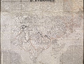
ZUDA ROKASHI (Priest Motan). - Nansenbushu bankoku shoka no zu" (Outline Map of all the Countries of the Universe).
Nouveau
ZUDA ROKASHI (Priest Motan). - Nansenbushu bankoku shoka no zu" (Outline Map of all the Countries of the Universe).
Date: Kyoto, "Hoei 7" (= Year of the Tiger = 1710
Format: 1145 x 1415mm.
Color: Noir et blanc.
Condition: Strong impression, printed on several sheets of native paper, joined. Some worming, and pin holes on old crossing of foldings. Folded as usual and mounted on 2 blue cardboards with title-piece. (size 240x180mm), in modern linen case.
Description
This map is a great example for Japanese world maps representing Buddhist cosmology with real world cartography. It is the earliest one and - therefore - the prototype for Buddhist world maps.
They all represent a large, imaginary India, where Buddha was born, as the heart of the world, but also depictions of Europe and the New World.
At the time being, Japan maintained an isolationist policy which began in 1603 with the Edo period under the military ruler Tokugawa Ieyasu, and lasting for nearly 270 years. Although knowing the world map by Matteo Ricci, published in Peking in 1602, Japanese maps mainly showed a purely Sino-centric view - or with acknowledgement of Buddhist traditional teaching - the Buddhist habitable world with an identifiable Indian sub-continent.
The map was drawn by the scholar-priest Zuda Rokashi, founder of Kegonji Temple in Kyoto, and illustrates the fusion of existing Buddhist and poorly known European cartography. The language is Chinese, except for a few Japanese characters on the illustrations of European countries.
Europe is shown at upper left as a group of islands, which can be identified from Iceland to England, Scandinavia, Poland, Hungary and Turkey, but deliberately deleting the Iberian Peninsula. At lower right South America is featured as an island south of Japan with a small peninsula as part of Central America, carrying among just a few place-names also 4 Chinese characters whose phonetical Japanese reading is "A-ME-RI-KA". North of Japan, a land bridge joints Asia with an unnamed landmass, presumably North America. Africa is not shown at all.
On the other hand, this map is much more than a world map and the main concept by the author was to celebrate a historically very important event. The map echoes the pilgrimage route of the famous Chinese Buddhist priest Hsuan-Tsang (or Xuan Zhuang, Genjo in Japanese; 602-664 A.D.), who travelled to India to visit sacred places of Buddhism and also to collect holy sanskrit writings. So the largest part of the map is depicted to "Jambu-Dvipa" with the sacred Lake of Anavatapta (Lake Manasarovar in the Himalayas) at center, from which the 4 rivers Ganges, Oxus, Indus and Tarim are flowing. This all was based on the Japanese version of Hsuan-Tsang's Chinese narrative, the Si-yu-ki, printed as late as 1653. Here numerous details are given, including the interesting feature of the so-called "iron-gate", shown as a strongly over-sized square, and the path taken by the monk whilst crossing the forbidden mountain systems after leaving Samarkand.
Also, at the upper left corner 102 references from Buddhist holy writings and Chinese annals are mentioned to increase the credibility of the map. Folded as usual and mounted on 2 blue cardboards with title-piece (size: 240x180mm, slightly spotted and scraped).
The first buddhist world map printed in Japan and the prototype for all subsequent Buddhist world maps printed in Japan until the late nineteenth century. The author, Hotan (1654-1728), was a scholar-priest and founder of the Kegonji Temple in Kyoto. The earliest known example in Japan is the Gotenjiku Zu (Map of the Five Indies) by the priest Jukai dating from 1364 and now preserved in Horyuji Temple in Nara. However Hotan’s map was revolutionary in being the first printed Oriental map to introduce detailed Western cartographic information into this traditional Buddhist cosmological view and to attempt to merge the two together into a comprehensible form. Europe is depicted as a series of islands in the upper left of the image whilst South America is likewise another island in the lower right of the image. Africa is omitted completely. China and Japan are clearly defined in the upper right of the map. The popularity of the map is evidenced by the fact that although the map is dated 1710, it was reissued unchanged in numerous editions through to about 1815 and spawned innumerable copies and derivatives over the next 150 years. a rare and important cartographic work.
Reference : K Yamashita, Japanese Maps of the Edo Period, pp.32-33 ill. Nanba, Old Maps in Japan ill. 8. K.Unno, Cartography in Japan, 1994, page. 346-477 and illustration 11.59. Cortazzi, Isle of Gold page 38 and col.ill. 48. Beans Coll. 1710.1. Kerlen 44, Muroga & Unno, “The Buddhist World Map in Japan”, in IM XVI (1962). Harley & Woodward, The History of Cartography, 2.2, pp.428ff and ill.. 11.59.
They all represent a large, imaginary India, where Buddha was born, as the heart of the world, but also depictions of Europe and the New World.
At the time being, Japan maintained an isolationist policy which began in 1603 with the Edo period under the military ruler Tokugawa Ieyasu, and lasting for nearly 270 years. Although knowing the world map by Matteo Ricci, published in Peking in 1602, Japanese maps mainly showed a purely Sino-centric view - or with acknowledgement of Buddhist traditional teaching - the Buddhist habitable world with an identifiable Indian sub-continent.
The map was drawn by the scholar-priest Zuda Rokashi, founder of Kegonji Temple in Kyoto, and illustrates the fusion of existing Buddhist and poorly known European cartography. The language is Chinese, except for a few Japanese characters on the illustrations of European countries.
Europe is shown at upper left as a group of islands, which can be identified from Iceland to England, Scandinavia, Poland, Hungary and Turkey, but deliberately deleting the Iberian Peninsula. At lower right South America is featured as an island south of Japan with a small peninsula as part of Central America, carrying among just a few place-names also 4 Chinese characters whose phonetical Japanese reading is "A-ME-RI-KA". North of Japan, a land bridge joints Asia with an unnamed landmass, presumably North America. Africa is not shown at all.
On the other hand, this map is much more than a world map and the main concept by the author was to celebrate a historically very important event. The map echoes the pilgrimage route of the famous Chinese Buddhist priest Hsuan-Tsang (or Xuan Zhuang, Genjo in Japanese; 602-664 A.D.), who travelled to India to visit sacred places of Buddhism and also to collect holy sanskrit writings. So the largest part of the map is depicted to "Jambu-Dvipa" with the sacred Lake of Anavatapta (Lake Manasarovar in the Himalayas) at center, from which the 4 rivers Ganges, Oxus, Indus and Tarim are flowing. This all was based on the Japanese version of Hsuan-Tsang's Chinese narrative, the Si-yu-ki, printed as late as 1653. Here numerous details are given, including the interesting feature of the so-called "iron-gate", shown as a strongly over-sized square, and the path taken by the monk whilst crossing the forbidden mountain systems after leaving Samarkand.
Also, at the upper left corner 102 references from Buddhist holy writings and Chinese annals are mentioned to increase the credibility of the map. Folded as usual and mounted on 2 blue cardboards with title-piece (size: 240x180mm, slightly spotted and scraped).
The first buddhist world map printed in Japan and the prototype for all subsequent Buddhist world maps printed in Japan until the late nineteenth century. The author, Hotan (1654-1728), was a scholar-priest and founder of the Kegonji Temple in Kyoto. The earliest known example in Japan is the Gotenjiku Zu (Map of the Five Indies) by the priest Jukai dating from 1364 and now preserved in Horyuji Temple in Nara. However Hotan’s map was revolutionary in being the first printed Oriental map to introduce detailed Western cartographic information into this traditional Buddhist cosmological view and to attempt to merge the two together into a comprehensible form. Europe is depicted as a series of islands in the upper left of the image whilst South America is likewise another island in the lower right of the image. Africa is omitted completely. China and Japan are clearly defined in the upper right of the map. The popularity of the map is evidenced by the fact that although the map is dated 1710, it was reissued unchanged in numerous editions through to about 1815 and spawned innumerable copies and derivatives over the next 150 years. a rare and important cartographic work.
Reference : K Yamashita, Japanese Maps of the Edo Period, pp.32-33 ill. Nanba, Old Maps in Japan ill. 8. K.Unno, Cartography in Japan, 1994, page. 346-477 and illustration 11.59. Cortazzi, Isle of Gold page 38 and col.ill. 48. Beans Coll. 1710.1. Kerlen 44, Muroga & Unno, “The Buddhist World Map in Japan”, in IM XVI (1962). Harley & Woodward, The History of Cartography, 2.2, pp.428ff and ill.. 11.59.
15 000€
- N° Reference: 30192
900€
1 200€
Some of the most asked FAQ by our clients
Librairie Loeb-Larocque specializes in maps, atlases, and travel books from the 16th to 19th centuries.
The Librairie was founded in 1958 by Louis Loeb-Larocque. Originally, he arrived in France from Germany shortly after World War II. He started an antiquarian map and book shop in Paris, specializing in early maps, atlases, travel books, and prints. The shop was located at Rue Le Peletier until 1996, and was frequently visited by collectors and fellow dealers from all parts of the world.
At present, the office is located at 31 rue de Tolbiac in Paris in the lively 13th district, a 5-minute walk from the Bibliothéque Nationale de France (Metro Line 14)
Visitors are welcome to our shop by appointment, Monday through Friday.
The Librairie was founded in 1958 by Louis Loeb-Larocque. Originally, he arrived in France from Germany shortly after World War II. He started an antiquarian map and book shop in Paris, specializing in early maps, atlases, travel books, and prints. The shop was located at Rue Le Peletier until 1996, and was frequently visited by collectors and fellow dealers from all parts of the world.
At present, the office is located at 31 rue de Tolbiac in Paris in the lively 13th district, a 5-minute walk from the Bibliothéque Nationale de France (Metro Line 14)
Visitors are welcome to our shop by appointment, Monday through Friday.
Librairie Loeb-Larocque sells authentic maps, prints, atlases, and rare books. We guarantee the authenticity and condition of each lot listed in our catalogs.
Browse the catalog now >>>
We supply a certificate for each item sold. Librairie Loeb-Larocque guarantees the authenticity and condition of each lot described in our catalogs.
The warranty has no time limit. Defects in lots offered for sale have been carefully noted.
Sauf indication contraire, toutes les cartes sont des gravures sur cuivre ou des eaux-fortes.
· Col. ancien/d’époque signifie que le lot a été colorié lors (ou aux environs) de sa publication,
- col. signifie que le lot a été colorié récemment.
Browse the catalog now >>>
· Col. ancien/d’époque signifie que le lot a été colorié lors (ou aux environs) de sa publication,
- col. signifie que le lot a été colorié récemment.
Browse the catalog now >>>
The value of any rare book, atlas, globe, print, or map is affected by many factors: its rarity, condition, binding, provenance, and the significance of any inscriptions it may contain.
Béatrice Loeb-Larcque, an expert and member of the Syndicat Français des Experts Professionnels en Œuvres d'Art et Objets de Collection, provides a free appraisal if you are considering selling.
We provide auction estimates based on photographs sent via the Internet. These estimates are not for valuation purposes and are subject to revision upon inspection of the object.
It is impossible to provide verbal estimates by telephone, nor can we respond to requests sent without a photo.
There is no easy answer to this question. Some books or maps have, without question, appreciated considerably in value over the years.
Others have remained steadily desirable without seeing a significant rise in price, and still others can be purchased for little money but give great personal satisfaction.
Librairie Loeb-Larocque, with 60 years of experience in the rare map and book trade, can help you decide what kind of collection you would like to build.
Others have remained steadily desirable without seeing a significant rise in price, and still others can be purchased for little money but give great personal satisfaction.
Librairie Loeb-Larocque, with 60 years of experience in the rare map and book trade, can help you decide what kind of collection you would like to build.
Nous recherchons en permanence pour nos clients et notre stock des ouvrages et cartes rares dans nos domaines de spécialités : atlas, cartes géographiques, voyages et livres illustrés.
Si vous avez des ouvrages et des cartes à vendre dans l’un de ces domaines, ou bien une bibliothèque complète, veuillez consulter la liste ci-dessous, qui vous donnera un aperçu de ce que nous recherchons.
DO A FREE APPRAISAL >>>
Si vous avez des ouvrages et des cartes à vendre dans l’un de ces domaines, ou bien une bibliothèque complète, veuillez consulter la liste ci-dessous, qui vous donnera un aperçu de ce que nous recherchons.
DO A FREE APPRAISAL >>>
En vertu des dispositions des articles L.121-20-12 et suivants du Code de la Consommation, le client dispose d'un délai de quatorze jours francs pour exercer son droit de rétractation sans avoir à justifier de motifs, à compter de la date de réception de sa commande. Les frais d'envoi et de retour seront à la charge du client. Les produits, accompagnés d'un RIB du client, devront être retournés par la Poste, dans un parfait état et dans leur emballage d'origine à l'adresse suivante : 31 rue de Tolbiac, 75013.
Les remboursements s'effectueront par crédit de la carte bancaire du client, dans un délai de 3 jours. En cas de retour d'un produit endommagé, incomplet ou abîmé, celui-ci ne sera ni échangé ni remboursé.
Browse the catalog now >>>
Les remboursements s'effectueront par crédit de la carte bancaire du client, dans un délai de 3 jours. En cas de retour d'un produit endommagé, incomplet ou abîmé, celui-ci ne sera ni échangé ni remboursé.
Browse the catalog now >>>
Les commandes peuvent être livrées n'importe où dans le monde. Les commandes seront livrées par DHL, par Colissimo ou un autre opérateur.
La livraison des produits ne sera effective qu'après encaissement du montant total de la commande. Les produits seront livrés à l'adresse indiquée par le client, au moment du passage de sa commande.
- Livraison France métropolitaine : Les commandes seront livrées en DHL pour 25 euros, ou Colissimo pour 20,00 Euros. Le délai de livraison moyen est de 1-3 jours ouvrés.
- Livraison Europe : Les commandes seront livrées en DHL pour 25,00 Euros. Le délai de livraison moyen est de 2-4 jours ouvrés.
- Livraison hors Europe : Les commandes seront livrées par DHL pour 25,00 Euros. Le délai de livraison moyen est de 2 - 5 jours ouvrés. Le délai est indiqué seulement à titre indicatif et ne constitue pas un engagement ferme de notre part.
Browse the catalog now >>>
La livraison des produits ne sera effective qu'après encaissement du montant total de la commande. Les produits seront livrés à l'adresse indiquée par le client, au moment du passage de sa commande.
- Livraison France métropolitaine : Les commandes seront livrées en DHL pour 25 euros, ou Colissimo pour 20,00 Euros. Le délai de livraison moyen est de 1-3 jours ouvrés.
- Livraison Europe : Les commandes seront livrées en DHL pour 25,00 Euros. Le délai de livraison moyen est de 2-4 jours ouvrés.
- Livraison hors Europe : Les commandes seront livrées par DHL pour 25,00 Euros. Le délai de livraison moyen est de 2 - 5 jours ouvrés. Le délai est indiqué seulement à titre indicatif et ne constitue pas un engagement ferme de notre part.
Browse the catalog now >>>
Nos locaux sont situés au 31 rue de Tolbiac, dans le 13ème arrondissement de Paris, à 300 m du métro Bibliothèque François Mitterrand (ligne 14).
Nous recevons exclusivement sur rendez-vous du lundi au vendredi de 9h à 19h..
CONTACT US
Nous recevons exclusivement sur rendez-vous du lundi au vendredi de 9h à 19h..
CONTACT US