Menu
Menu
Your Cart

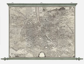
BRETEZ, Louis / TURGOT. - Plan de Paris commencé l'année 1734, Dessiné et gravé sous les ordres de Messire Michel Etienne Turgot, prévost des marchands.
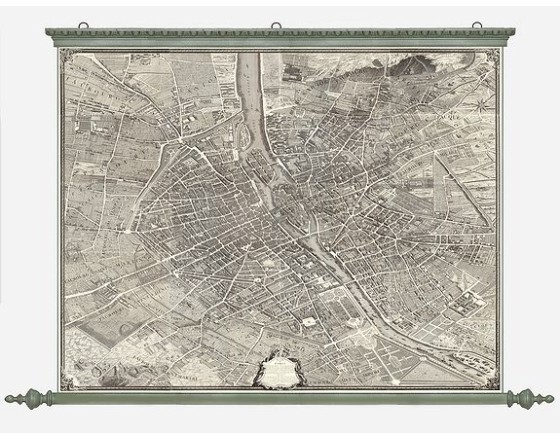
BRETEZ, Louis / TURGOT. -  Plan de Paris commencé l'année 1734, Dessiné et gravé sous les ordres de Messire Michel Etienne Turgot, prévost des marchands.
BRETEZ, Louis / TURGOT. - Plan de Paris commencé l'année 1734, Dessiné et gravé sous les ordres de Messire Michel Etienne Turgot, prévost des marchands.
Published: Paris, 1739
Size: 2580 x 3550mm.
Color: Uncoloured.
Condition: Very dark impression. Recently mounted on canvas with wooden rollers, linen ribbon on left and right margins. Size of the map image 2505 x 32250mm. In mint condition.

Description

FIRST EDITION of Turgot's Monumental Joined View of Paris, stretching to over 10 Feet.This expansive engraved view of Paris covers the first eleven arrondissements of modern Paris. With a combined width of over ten feet, this archivally joined plan makes for an arresting centerpiece. Turgot's is perhaps the best record of Paris in the 18th century, before its transformation by Georges-Eugène Haussmann and Emperor Napoleon III. It is widely regarded as one of the most important city views of all time.

Sold with the index plan, also laid down on canvas with wooden rollers.

The Mayor of Paris, Michel-Étienne Turgot, commissioned Louis Bretez, a member of the Académie de Saint-Luc to create an impressive image of the city. He was given license to survey wherever he needed and could enter private property if the task required. The end result was to be a statement piece, one which was presented to dignitaries, foreign and domestic alike, to reinforce their esteem of Paris.
Historians suspect that Bretez was awarded the commission in part because of the work he had already done on architectural perspective, some of which was published in his 1706 book La perspective pratique de l'architecture .

Claude Lucas, engraver of the Royal Academy of Sciences, masterfully engraved the plan, which was published between 1739 and 1740. The map was bound in elegant volumes and offered to the King, the members of the Academy, the Municipality, and important visiting dignitaries. Those examples assembled and hung on the wall generally didn't survived.

PLEASE NOTE: The illustration provided is a digital composite of another example of the map ( David Rumsey Collection 10059 ). We are happy to provide images of parts upon request.

19,500€

Some of the most asked FAQ by our clients

Librairie Loeb-Larocque specializes in maps, atlases, and travel books from the 16th to 19th centuries.
The Librairie was founded in 1958 by Louis Loeb-Larocque. Originally, he arrived in France from Germany shortly after World War II. He started an antiquarian map and book shop in Paris, specializing in early maps, atlases, travel books, and prints. The shop was located at Rue Le Peletier until 1996, and was frequently visited by collectors and fellow dealers from all parts of the world.
At present, the office is located at 31 rue de Tolbiac in Paris in the lively 13th district, a 5-minute walk from the Bibliothéque Nationale de France (Metro Line 14).
We welcome visitors to our shop by appointment, Monday through Friday.

MORE ABOUT LOEB-LAROCQUE
Librairie Loeb-Larocque sells authentic maps, prints, atlases, and rare books. We guarantee the authenticity and condition of each lot listed in our catalogs.
Browse the catalog now >>>
We supply a certificate for each item sold. Librairie Loeb-Larocque fully guarantees the authenticity and condition of each lot described in our catalogs. The warranty is unlimited in time. Defects in lots offered for sale have been carefully noted.
The term "color" means that the color is applied by hand.
- "Original colors / col. ancien-d' époque" means that the item was colored at or about the time of publication.
- "Colored/color" means that the map has recently been hand-colored within the last 50 years.

Measurements are given in centimeters; height is given first, excluding margins. Size is mentioned of the plate mark; height is given first. When there is no plate mark, we take the sizes of the illustration. In some instances, we additionally mention the size of the sheet in the condition field.

The date and place mentioned in our catalog is the date when the item was made and published. Where the publishing date is approximate, then c. (circa) is used.
We do not sell reproductions!

Browse the catalog now >>>
The value of a rare book, atlas, globe, print, or map depends on rarity, condition, binding, provenance, and the significance of any inscriptions it may contain. Béatrice Loeb-Larcque, an expert and member of the Syndicat Français des Experts Professionnels en Œuvres d'Art et Objets de Collection, provides a free appraisal if you are considering selling. We provide auction estimates from photographs sent via the Internet. These estimates are not for valuation purposes and are subject to revision upon inspection of the object. It is impossible to provide verbal estimates over the phone, nor can we respond to requests without a photo.

DO A VALUATION >>>
There is no easy answer to this question. Some books or maps have, without question, appreciated considerably in value over the years.
Others have remained steadily desirable without seeing a significant rise in price, and still others can be purchased for little money but give great personal satisfaction.
Librairie Loeb-Larocque, with 60 years of experience in the rare map and book trade, can help you decide what kind of collection you would like to build.
We buy antiquarian books in our areas of specialization: Atlases, old maps, travel books, and illustrated books.
If you want to sell books and maps, contact us for a free estimate. Send us photos by email, or make an appointment for a physical examination of the object. We will then make a purchase offer.

DO A FREE APPRAISAL >>>
Following the European Consumer Rights Directive, a buyer habitually residing in the European Union has the right to cancel the contract for the purchase of an item, without giving any reason.
The cancellation period will expire 14 calendar days from the day after the date on which you or a third party (other than the carrier and indicated by you) acquires physical possession of the lot.
To exercise the right to cancel, you must inform Joppen et Loeb Associates SARL, which is offering to sell the lot either as an agent for the seller or as the owner of the lot, of your decision to cancel this contract by a clear statement (e.g. a letter sent by post, 31 rue de Tolbiac, 75013 Paris France or e-mail (info @ loeb-larocque.com).


Browse the catalog now >>>
Parcels are shipped by DHL or registered mail and must be signed for. Insurance is included.
- We charge a flat shipping fee of 15 euros for shipments within France for shipments up to one kg.
- For parcels shipped within Europe, a flat 25,00 euros is charged.
-For shipments outside of Europe, the postal fee is 25.00 euros for the USA and Asia
- 45.00 euros for Africa and Australia for parcels up to one kg. Heavier parcels are shipped at a nominal postal fee.

Items are fully insured and usually shipped the day following payment. We ship maps and prints in sturdy tubes or strong packaging if necessary.

The items are shipped when your payment is received.
Browse the catalog now >>>
Visitors are welcome to our shop by appointment, Monday through Friday from 9 AM to 7 PM. We participate in fairs in Amsterdam, London, Venice, and often travel to find interesting items. Registered users receive monthly email updates. Follow us on Instagram or Facebook.
CONTACT US