SALAMANCA, Antonio. - La dimostratione del luogo dove al presente sitrova l'armat di Barbarossa, et de Christiani detto il golfo dell 'Artha anti ch amente il sino ambracio…
Published: Rome, c. 1540
Size: 300 x 440mm.
Color: Uncolored
Condition: Two small cracks at bottom of the map with lightly browned spots due to old restorations with adhesive paper, a few tiny scattered wormholes. Good and dark impression.
Description
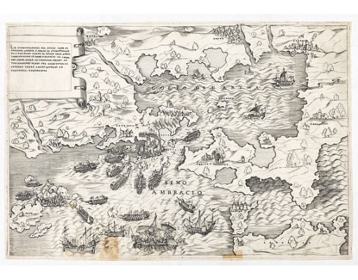
The title cartouche at the top left reads: "La Dimostratione Del Luogo Dove Al Presente Sitrova L'Armat Di Barbarossa, et De Christiani Detto Il Golfo Dell' Artha Antichamente Il Seno Ambracio Da Ambracia Citta Reale Di Pylrrho Vicino Al Promontorio Actio Per Lavictoria Di Augusto Contra Marc Antonio et Cleopatra Memorabile [The Demonstration of the Place Where the Fleet of Barbarossa is Currently Located, and of the Christians, Called the Gulf of Artha, in the Past the Ambracian Gulf, from Ambracia, a Royal City of Pyrrhus, Near the Promontory of Actium, Memorable for the Victory of Augustus Against Mark Antony and Cleopatra.
Very Rare Map Showing the Largest Naval Battle of the First Half of the Sixteenth Century -- And The Site of Octavius' Historic Battle with Antony and Cleopatra.
A rare and vibrant map of the Gulf of Artha showing the pivotal Battle of Preveza, engraved in Rome by Antonio Salamanca, also includes historical references to the Battle of Actium, which pitted Octavius against Antony and Cleopatra.
"Fought in 1538, the Battle of Preveza pitted the famed Ottoman commander and former pirate, Hayreddin Barbarossa, against a combined Holy League consisting of Spanish, Papal, Genoese, Venetian, and Maltese ships led by Andrea Doria. The Ottoman victory cemented Ottoman supremacy in the Mediterranean until the Battle of Lepanto in 1571 and is generally considered the largest naval battle of the 16th century until Lepanto in 1571.
The map shows the strategic geographic feature on the western side of the Greek peninsula, just south of Corfu. The waters are shown in three ways: shallow bays are marked with dashed parallel lines, calm waters and deeper inlets have solid parallel lines, and deep, open waters are shown as rolling waves.
It is on these waves that the action of the battle took place. Galleys rowed by slaves maraud the waters, mounted with artillery in their bows. Both sides had such galleys, but they were the principal vessels of the Ottoman forces, giving them an advantage in maneuverability.
The sailing ships were chiefly under the command of the Holy League, making them dependent on the winds. This dependency came with a price, as seen here. The image shows crewmen frantically trying to unfurl sails in one ship while others are shown leaping from a burning vessel, its sails alight. Although this was primarily a naval battle, some Ottoman troops were stationed on land, as seen here with their camp behind Preveza. Other settlements nearby are reduced to smoking ruins.
Interestingly, a faint “37” is printed in the waters near the ship in the top right corner. The meaning of this number is unknown. The rest of the script printed here was achieved using letter punches.
While the map is unsigned, experts confidently attribute the work to Salamanca. Antony and Cleopatra in Actium.
While the 1538 battle was decisive, the upper left cartouche reminds the viewer of much older events. The gulf used to be known as the Gulf of Ambracio, and it housed the city of Pyrrhus in the fourth century BCE. Another naval engagement took place nearby, this one between Octavius and the legendary Antony and Cleopatra.
When Antony and Cleopatra joined forces in 41 BCE, the former’s relationship with Octavius, Julius Caesar’s chosen heir, grew strained. A decade later, Octavius declared war against Cleopatra. Their forces met in at the Battle of Actium, which is across the strait from Preveza. It is marked here with the temple of Apollo that stood in ancient Actium.
The superior forces of Octavius overwhelmed those of Antony and Cleopatra. The two separately broke through the enemy’s ranks and fled. This decisive defeat spelled doom for the couple. Within a year, Octavius attacked Alexandria. After the battle, which Antony lost, he was told that Cleopatra had died. Distraught, he stabbed himself, only to be told that she still lived. He lived long enough to tell her to make peace. She spoke with Octavius, but then committed suicide herself.
Barbarossa and the Battle of Preveza
The battle depicted here was no less monumental than that fought by Antony and Cleopatra fifteen hundred years earlier. Its protagonists included the most notorious pirate and naval commander of the Ottoman Empire, Hayreddin Barbarossa. The son of a successful potter and merchant from Lesbos, Khiḍr, as he was named, and his brothers initially took to sea to trade legitimately. However, as tensions rose between Christian and Ottoman forces, especially in North Africa, the brothers became privateers under the command of Korkud, a son of the Ottoman sultan Bayezid II.
Eager to avoid the politics of regime change in the Ottoman Empire, the brothers settled in North Africa and raided from there. In 1516, they took Algiers. This victory drew Ottoman attention and the brothers increasingly worked alongside and within the empire's operations. Khiḍr became known as Barbarossa, or Red Beard, and was named governor of Rhodes in 1522. He also took Tunis in 1531. After scattering a Christian force under Genoese Admiral Andrea Doria, Khiḍr was granted the title of Hayreddin, or best of the faith. Soon thereafter, Pope Paul III assembled a Holy League to take on Barbarossa. Ironically, Doria was placed at the head of 112 galleys, 50 galleons, 140 barks, and 60,000 soldiers. Barbarossa, sailing to meet him, had 122 galleys and galliots with 12,000 soldiers—he was outnumbered three ships to one.
After attempts to dislodge the Ottomans from their strongholds at Preveza and Actium, Doria drew his fleet away. Barbarossa approached the back of the overextended Holy League ships at dawn of September 27, 1538, throwing them into disarray. He attacked the Venetians and Maltese, who thought Doria was coming to support them. Left adrift with no wind, the ships fought. The Ottomans had swifter, more agile vessels, but the Venetians had a massive flagship that could fire double broadsides.
Doria attempted to draw Barbarossa out to sea, but the Ottoman commander was too clever to abandon the shelter of the coast. On the morning of the 28th, Doria sailed for Corfu, where the Venetian flagship had limped, abandoning the battle. Barbarossa had won. His ships sank ten Holy League vessels, burned three, and captured 3,000 prisoners. Comparably, he lost no ships, although some were damaged, with 400 dead and 800 wounded. The battle established Ottoman naval supremacy for the next three decades". [Source: raremaps.com]
Very Rare Map Showing the Largest Naval Battle of the First Half of the Sixteenth Century -- And The Site of Octavius' Historic Battle with Antony and Cleopatra.
A rare and vibrant map of the Gulf of Artha showing the pivotal Battle of Preveza, engraved in Rome by Antonio Salamanca, also includes historical references to the Battle of Actium, which pitted Octavius against Antony and Cleopatra.
"Fought in 1538, the Battle of Preveza pitted the famed Ottoman commander and former pirate, Hayreddin Barbarossa, against a combined Holy League consisting of Spanish, Papal, Genoese, Venetian, and Maltese ships led by Andrea Doria. The Ottoman victory cemented Ottoman supremacy in the Mediterranean until the Battle of Lepanto in 1571 and is generally considered the largest naval battle of the 16th century until Lepanto in 1571.
The map shows the strategic geographic feature on the western side of the Greek peninsula, just south of Corfu. The waters are shown in three ways: shallow bays are marked with dashed parallel lines, calm waters and deeper inlets have solid parallel lines, and deep, open waters are shown as rolling waves.
It is on these waves that the action of the battle took place. Galleys rowed by slaves maraud the waters, mounted with artillery in their bows. Both sides had such galleys, but they were the principal vessels of the Ottoman forces, giving them an advantage in maneuverability.
The sailing ships were chiefly under the command of the Holy League, making them dependent on the winds. This dependency came with a price, as seen here. The image shows crewmen frantically trying to unfurl sails in one ship while others are shown leaping from a burning vessel, its sails alight. Although this was primarily a naval battle, some Ottoman troops were stationed on land, as seen here with their camp behind Preveza. Other settlements nearby are reduced to smoking ruins.
Interestingly, a faint “37” is printed in the waters near the ship in the top right corner. The meaning of this number is unknown. The rest of the script printed here was achieved using letter punches.
While the map is unsigned, experts confidently attribute the work to Salamanca. Antony and Cleopatra in Actium.
While the 1538 battle was decisive, the upper left cartouche reminds the viewer of much older events. The gulf used to be known as the Gulf of Ambracio, and it housed the city of Pyrrhus in the fourth century BCE. Another naval engagement took place nearby, this one between Octavius and the legendary Antony and Cleopatra.
When Antony and Cleopatra joined forces in 41 BCE, the former’s relationship with Octavius, Julius Caesar’s chosen heir, grew strained. A decade later, Octavius declared war against Cleopatra. Their forces met in at the Battle of Actium, which is across the strait from Preveza. It is marked here with the temple of Apollo that stood in ancient Actium.
The superior forces of Octavius overwhelmed those of Antony and Cleopatra. The two separately broke through the enemy’s ranks and fled. This decisive defeat spelled doom for the couple. Within a year, Octavius attacked Alexandria. After the battle, which Antony lost, he was told that Cleopatra had died. Distraught, he stabbed himself, only to be told that she still lived. He lived long enough to tell her to make peace. She spoke with Octavius, but then committed suicide herself.
Barbarossa and the Battle of Preveza
The battle depicted here was no less monumental than that fought by Antony and Cleopatra fifteen hundred years earlier. Its protagonists included the most notorious pirate and naval commander of the Ottoman Empire, Hayreddin Barbarossa. The son of a successful potter and merchant from Lesbos, Khiḍr, as he was named, and his brothers initially took to sea to trade legitimately. However, as tensions rose between Christian and Ottoman forces, especially in North Africa, the brothers became privateers under the command of Korkud, a son of the Ottoman sultan Bayezid II.
Eager to avoid the politics of regime change in the Ottoman Empire, the brothers settled in North Africa and raided from there. In 1516, they took Algiers. This victory drew Ottoman attention and the brothers increasingly worked alongside and within the empire's operations. Khiḍr became known as Barbarossa, or Red Beard, and was named governor of Rhodes in 1522. He also took Tunis in 1531. After scattering a Christian force under Genoese Admiral Andrea Doria, Khiḍr was granted the title of Hayreddin, or best of the faith. Soon thereafter, Pope Paul III assembled a Holy League to take on Barbarossa. Ironically, Doria was placed at the head of 112 galleys, 50 galleons, 140 barks, and 60,000 soldiers. Barbarossa, sailing to meet him, had 122 galleys and galliots with 12,000 soldiers—he was outnumbered three ships to one.
After attempts to dislodge the Ottomans from their strongholds at Preveza and Actium, Doria drew his fleet away. Barbarossa approached the back of the overextended Holy League ships at dawn of September 27, 1538, throwing them into disarray. He attacked the Venetians and Maltese, who thought Doria was coming to support them. Left adrift with no wind, the ships fought. The Ottomans had swifter, more agile vessels, but the Venetians had a massive flagship that could fire double broadsides.
Doria attempted to draw Barbarossa out to sea, but the Ottoman commander was too clever to abandon the shelter of the coast. On the morning of the 28th, Doria sailed for Corfu, where the Venetian flagship had limped, abandoning the battle. Barbarossa had won. His ships sank ten Holy League vessels, burned three, and captured 3,000 prisoners. Comparably, he lost no ships, although some were damaged, with 400 dead and 800 wounded. The battle established Ottoman naval supremacy for the next three decades". [Source: raremaps.com]
7,500€
- Reference N°: 49074
Some of the most asked FAQ by our clients
Librairie Loeb-Larocque specializes in maps, atlases, and travel books from the 16th to 19th centuries.
The Librairie was founded in 1958 by Louis Loeb-Larocque. Originally, he arrived in France from Germany shortly after World War II. He started an antiquarian map and book shop in Paris, specializing in early maps, atlases, travel books, and prints. The shop was located at Rue Le Peletier until 1996, and was frequently visited by collectors and fellow dealers from all parts of the world.
At present, the office is located at 31 rue de Tolbiac in Paris in the lively 13th district, a 5-minute walk from the Bibliothéque Nationale de France (Metro Line 14).
We welcome visitors to our shop by appointment, Monday through Friday.
MORE ABOUT LOEB-LAROCQUE
The Librairie was founded in 1958 by Louis Loeb-Larocque. Originally, he arrived in France from Germany shortly after World War II. He started an antiquarian map and book shop in Paris, specializing in early maps, atlases, travel books, and prints. The shop was located at Rue Le Peletier until 1996, and was frequently visited by collectors and fellow dealers from all parts of the world.
At present, the office is located at 31 rue de Tolbiac in Paris in the lively 13th district, a 5-minute walk from the Bibliothéque Nationale de France (Metro Line 14).
We welcome visitors to our shop by appointment, Monday through Friday.
MORE ABOUT LOEB-LAROCQUE
Librairie Loeb-Larocque sells authentic maps, prints, atlases, and rare books. We guarantee the authenticity and condition of each lot listed in our catalogs.
Browse the catalog now >>>
We supply a certificate for each item sold. Librairie Loeb-Larocque fully guarantees the authenticity and condition of each lot described in our catalogs. The warranty is unlimited in time. Defects in lots offered for sale have been carefully noted.
The term "color" means that the color is applied by hand.
- "Original colors / col. ancien-d' époque" means that the item was colored at or about the time of publication.
- "Colored/color" means that the map has recently been hand-colored within the last 50 years.
Measurements are given in centimeters; height is given first, excluding margins. Size is mentioned of the plate mark; height is given first. When there is no plate mark, we take the sizes of the illustration. In some instances, we additionally mention the size of the sheet in the condition field.
The date and place mentioned in our catalog is the date when the item was made and published. Where the publishing date is approximate, then c. (circa) is used.
We do not sell reproductions!
Browse the catalog now >>>
- "Original colors / col. ancien-d' époque" means that the item was colored at or about the time of publication.
- "Colored/color" means that the map has recently been hand-colored within the last 50 years.
Measurements are given in centimeters; height is given first, excluding margins. Size is mentioned of the plate mark; height is given first. When there is no plate mark, we take the sizes of the illustration. In some instances, we additionally mention the size of the sheet in the condition field.
The date and place mentioned in our catalog is the date when the item was made and published. Where the publishing date is approximate, then c. (circa) is used.
We do not sell reproductions!
Browse the catalog now >>>
The value of a rare book, atlas, globe, print, or map depends on rarity, condition, binding, provenance, and the significance of any inscriptions it may contain.
Béatrice Loeb-Larcque, an expert and member of the Syndicat Français des Experts Professionnels en Œuvres d'Art et Objets de Collection, provides a free appraisal if you are considering selling. We provide auction estimates from photographs sent via the Internet. These estimates are not for valuation purposes and are subject to revision upon inspection of the object.
It is impossible to provide verbal estimates over the phone, nor can we respond to requests without a photo.
DO A VALUATION >>>
DO A VALUATION >>>
There is no easy answer to this question. Some books or maps have, without question, appreciated considerably in value over the years.
Others have remained steadily desirable without seeing a significant rise in price, and still others can be purchased for little money but give great personal satisfaction.
Librairie Loeb-Larocque, with 60 years of experience in the rare map and book trade, can help you decide what kind of collection you would like to build.
Others have remained steadily desirable without seeing a significant rise in price, and still others can be purchased for little money but give great personal satisfaction.
Librairie Loeb-Larocque, with 60 years of experience in the rare map and book trade, can help you decide what kind of collection you would like to build.
We buy antiquarian books in our areas of specialization: Atlases, old maps, travel books, and illustrated books.
If you want to sell books and maps, contact us for a free estimate. Send us photos by email, or make an appointment for a physical examination of the object. We will then make a purchase offer.
DO A FREE APPRAISAL >>>
If you want to sell books and maps, contact us for a free estimate. Send us photos by email, or make an appointment for a physical examination of the object. We will then make a purchase offer.
DO A FREE APPRAISAL >>>
Following the European Consumer Rights Directive, a buyer habitually residing in the European Union has the right to cancel the contract for the purchase of an item, without giving any reason.
The cancellation period will expire 14 calendar days from the day after the date on which you or a third party (other than the carrier and indicated by you) acquires physical possession of the lot.
To exercise the right to cancel, you must inform Joppen et Loeb Associates SARL, which is offering to sell the lot either as an agent for the seller or as the owner of the lot, of your decision to cancel this contract by a clear statement (e.g. a letter sent by post, 31 rue de Tolbiac, 75013 Paris France or e-mail (info @ loeb-larocque.com).
Browse the catalog now >>>
The cancellation period will expire 14 calendar days from the day after the date on which you or a third party (other than the carrier and indicated by you) acquires physical possession of the lot.
To exercise the right to cancel, you must inform Joppen et Loeb Associates SARL, which is offering to sell the lot either as an agent for the seller or as the owner of the lot, of your decision to cancel this contract by a clear statement (e.g. a letter sent by post, 31 rue de Tolbiac, 75013 Paris France or e-mail (info @ loeb-larocque.com).
Browse the catalog now >>>
Parcels are shipped by DHL or registered mail and must be signed for. Insurance is included.
- We charge a flat shipping fee of 15 euros for shipments within France for shipments up to one kg.
- For parcels shipped within Europe, a flat 25,00 euros is charged.
-For shipments outside of Europe, the postal fee is 25.00 euros for the USA and Asia
- 45.00 euros for Africa and Australia for parcels up to one kg. Heavier parcels are shipped at a nominal postal fee.
Items are fully insured and usually shipped the day following payment. We ship maps and prints in sturdy tubes or strong packaging if necessary.
The items are shipped when your payment is received.
Browse the catalog now >>>
- We charge a flat shipping fee of 15 euros for shipments within France for shipments up to one kg.
- For parcels shipped within Europe, a flat 25,00 euros is charged.
-For shipments outside of Europe, the postal fee is 25.00 euros for the USA and Asia
- 45.00 euros for Africa and Australia for parcels up to one kg. Heavier parcels are shipped at a nominal postal fee.
Items are fully insured and usually shipped the day following payment. We ship maps and prints in sturdy tubes or strong packaging if necessary.
The items are shipped when your payment is received.
Browse the catalog now >>>
Visitors are welcome to our shop by appointment, Monday through Friday from 9 AM to 7 PM. We participate in fairs in Amsterdam, London, Venice, and often travel to find interesting items. Registered users receive monthly email updates. Follow us on Instagram or Facebook.
CONTACT US
CONTACT US