


-380x383w.jpg "Vichy - Boym map of China title")
-575x579h.jpg "Vichy - Boym map of China")
-575x579h.jpg "Vichy - Boym map of China")
-575x579h.jpg "Vichy Boym Phoenix")
-575x579h.jpg)
-380x383w.jpg "Boym Vichy Korea")
-380x383w.jpg)
-380x383w.jpg)
-380x383w.jpg)
-380x383w.jpg)

.jpg)
.jpg)
.jpg)
.jpg)
.jpg)
.jpg)
.jpg)
.jpg)
.jpg)
.jpg)
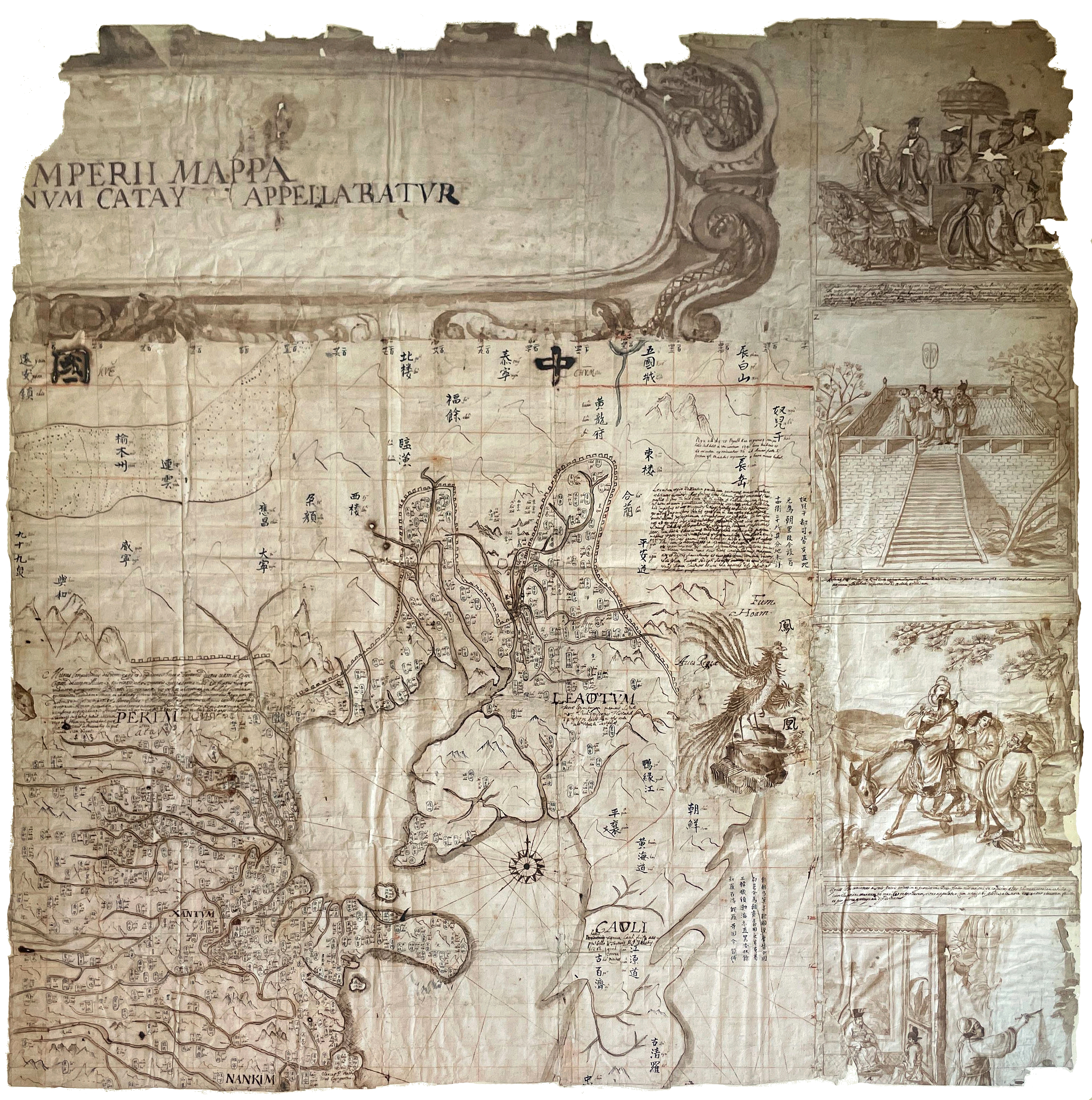
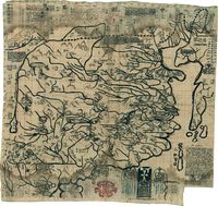
The Vichy Boym map of China
Auction on August 19 2023 at VICHY ENCHERES
Expert for the following lots: Béatrice Loeb-Larocque. Tel. +33 (0)6 11803375- info@loeb-larocque.com
Sold for euros 42,160 (Purchased by BNF)
MOST PROBABLY THE 4th KNOWN EXAMPLE IN MANUSCRIPT OF ONE OF THE MOST FAMOUS MAPS OF CHINA
produced by the Polish Jesuit Michael Boym, to convey Jesuits’ knowledge of the country to Europeans.
BOYM, Michal Piotr. (1612-1659).
…mperii Mappa…num Catay Appellabatur (Map of China).
Rome ?, ca. 1652-1656
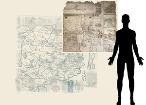
Part of a larger manuscript wall map on paper produced in black and brown pen and ink. Longitudes and latitudes are drawn in red ochre.
Dimensions of the map: 780 x 810 mm, total dimensions: 1100 x 1070 mm. ( 43x41 inches)
The title and the decorative border are trimmed. Old foldings, the upper right figure with some loss to the drawing due to oxidation of ink. Framed – not inspected out of the frame.
The conserved part, which we have called the "Vichy-Boym" map, shows the eastern part of China, including the Bohai Sea, Beijing and Tianjin regions. Much of Korea is shown inland, the Yalu River in North Korea, the Imjin River system, and the Seoul region. A Latin text occupies the center of Korea, entitled "CAULI".
Names are given in a Romanized form and in Chinese characters, an innovation that was to become common scientific practice.
The Chinese scholar, Andreas Chên, whom Boym brought to Italy as his assistant, may have written the Chinese names.
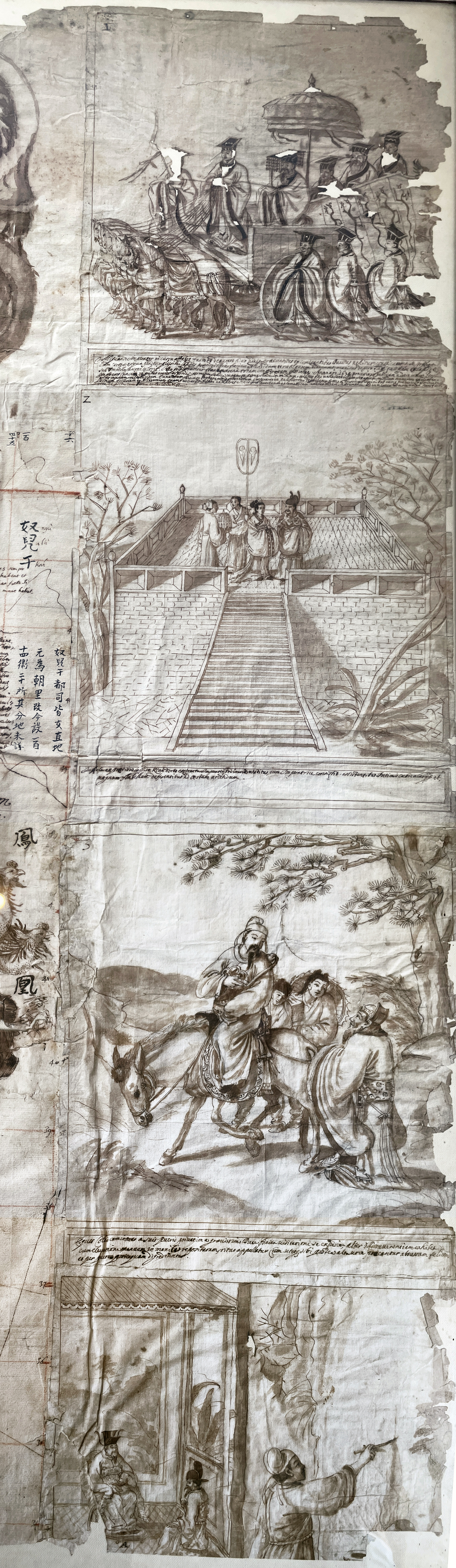
 What makes this example unique is that to the right, the map
has a border featuring four scenes with Latin captions relating to the Ming dynasty and,
more specifically, to the reign of the Chongzhen emperor: procession for the accession to the throne in 1628, the residence of the empress. At the top is a large decorative title cartouche in Latin and a compass rose near Korea.
What makes this example unique is that to the right, the map
has a border featuring four scenes with Latin captions relating to the Ming dynasty and,
more specifically, to the reign of the Chongzhen emperor: procession for the accession to the throne in 1628, the residence of the empress. At the top is a large decorative title cartouche in Latin and a compass rose near Korea.
The map also includes the longitudes and latitudes drawn in red ochre, a transcription of the Chinese geographical names accompanied by Romanized spelling.
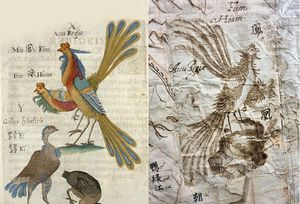
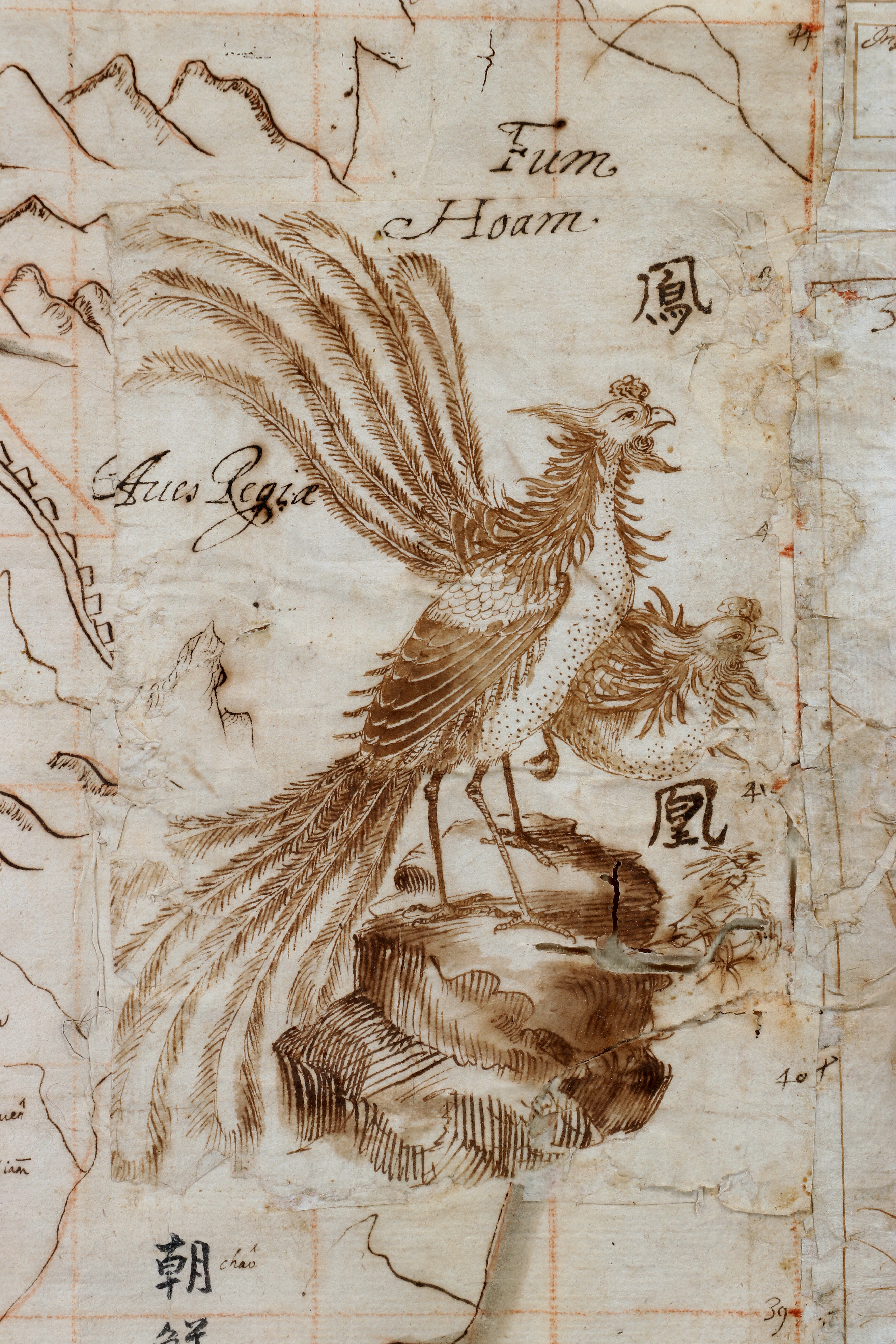
The map has extensive explanatory notes in Latin, mountains outlined in the European manner, a Phoenix, a musk deer, the Gobi Desert and the Great Wall.
The Phoenix (Avis Regia) and the head of the musk deer (Tusked Quadruped) are also represented in Flora Sinensis from 1656 and is one of the first (European) natural history books about China. The animals are drawn separately on paper strips and applied over the map. The Latin title has been corrected several times by applying paper strips and adding the letters in ink over them.
Provenance: Since the 18th century, the property of a family from Brittany, France.
Estimation € 30.000 - €40.000 / Sold for euros 42,160
There are three recorded versions of the general map of China by the prominent Polish priest and sinologue Michael Boym (1612-1659):
1) Mappa Imperii Sinarum of the Bibliothèque du Service Hydrographique de la Marine in Paris (lost during World War II)
2) A map that bears the Chinese title Chung kuo t'u [map of the Middle Kingdom] ( Sold at Sotheby’s in 1988, the current location is unknown)
3) and Sinarum Universalis Mappa, which constitutes the first general map of the Boym atlas in the Vatican Library, Fondo Borgia Cinese 531.
- Mappa Imperii Sinarum (Bibliothèque du Service Hydrographique de la Marine in Paris)
The map in Paris discovered by Pelliot was described by Robert Chabri in 1933. The map was found in the crypt of the Church of Notre Dame des Victoires in Paris, among the papers assembled from Versailles and from the monasteries suppressed during the Revolution.
This large and beautiful map of all China, Chabri affirms, was embellished with drawings and inscriptions which closely resemble the pictures of Boym’s Flora Sinensis (Father Boym’s famous botanical work from 1656), or the ones on the map preserved in the Vatican Library.
According to Boleslasw Szczesniak, the map disappeared under the German administration of the Bibliothèque during the occupation of Paris in 1940-1945. It was taken with other old manuscript maps and sent to Germany. As this map most probably originated from the Versailles collection, it should be, in my opinion, connected with the map of China published in 1670 by Pierre Mariette of Paris, and with the one made by the Royal Geographer of Louis XIV, Nicolas Sanson D’Abbeville (1600-1667). It is entitled: Abrégé de la Chine du R. P. Bouyn Iesuiste.
The cartographer, or his engraver, misspelled the name of Boym.
Sanson observed that the manuscript of the Boym map was considered by “the late M. Mariette, the Father, for engraving and publication; its Author esteeming it the best and most exact of the ones he ever had.” Sanson prepared it for publication, not, however, with confidence in its geographical exactness.
Sanson’s drawing of the Boym map is preserved in the Bibliothèque Nationale, Paris, in the Département des Cartes et Plans, Collection d’Anville, carton No. 7152. To this general map the author added a concise description of the Empire of China, Rerum Sinensium Compendiosa Descriptio. Szczesniak found this in the collection of MSS in the library of the Jesuit House of Studies, Les Fontaines, in Chantilly. The description came to this place, established after the restoration of the Society, from the celebrated house of Ste Genevieve in Paris. - Chung kuo t’u, or the map of the Middle Kingdom (The Library of Philips Robinson. Part II)
In the second Boym map of China, the handwriting on the map, all of the cartographical data, the embellishments, as well as the Chinese characters show the map to be practically identical to the one preserved in the Vatican Library. The similarity is enhanced by the very same technique of drawing used in the Boym atlas of the Borgia Cinese collection. This map, owned by Mr. Philip Robinson of Pall Mall in London, was acquired in 1824 by Sir Thomas Phillipps, the celebrated English bibliophile and collector.
Sir Thomas purchased it from the Dutch collector Gerhard Meerman, who in turn had acquired it in 1764 from the library of the Jesuit College at Clermont in Paris (which was later turned into the secular school, Lycée Louis-le-Grand), which also owned other Chinese manuscripts. It was later acquired by Phillip Robinson and sold at an auction by Sotheby’s in 1988, after which its whereabouts have been unknown.
This map is drawn on five sheets of paper pasted together to provide an area of around 60 x 60 inches, but the work measures 54.5 inches from top to bottom and 55.5 inches from side to side. It bears signs of an unfinished copy, however complete in its character. In comparison with the Vatican map the coloring is of inferior quality. It has no Latin title as other Boym’s maps have, only the Chinese characters Chung kuo t’u, or the map of the Middle Kingdom. This second copy presents a problem of several identifications.
According to Boleslasw Szczesniak it was drawn before 1653. Boym arrived in Italy from China in November 1652. The appearance on the map of the name Hai Chou in Manchuria, which was changed in 1653 to Hai Ch'eng Hsien, confirms Szczesniak’s supposition. But adding Fu [prefecture] to Fu Ning does not point to the date of 1734, when that prefecture was created.
According to Szczesniak it is only one of the “administrative” errors and mistakes made by the missionary cartographer. The handwriting and the calligraphic characteristics are those of the Boym map preserved in the Vatican Library. The Chinese characters, which are seen on the Vatican and the Robinson copies, are written by a Chinese hand. Boym brought with him to Italy his assistant, a “Chinese scholar”, Andreas Chen, who, perhaps, put the Chinese names on the map. -
 Sinarum Universalis Mappa (Vatican map)
The third map, the general map, and the first of the eighteen maps, in the Great Atlas of China by Michael Boym, is the prototype of his other maps of China. It is a cartographical piece of great elaboration: a beautiful and spectacular map, made during the age of cartographical lore.According to Szczesniak it should be dated 1652, the year Boym arrived in Italy as an ambassador of the Ming Pretender Yung Li. The title of the beautiful atlas is Magni Catay, Quod olim Serica, et modo Sinarum est Monarchia. Quindecim Regnorum. Octodecim Geographicae Tabulae. The title of the description of China preceding the maps is given as: Sinarum Imperii 160 regiones cum Regnorum confinium descriptione. No text is now attached to the Atlas, except a table of contents enumerating the titles of ten chapters, which are missing. The general map of the Atlas is considerably larger than the rest of the maps. It measures 85.5 cm wide and 83 cm long.
The Vatican map has three titles: 1) Sinarum Universalis Mappa; 2) Chung kuo t’u, or the map of the Middle Kingdom, where the Chinese characters stretch over the length of the upper sub-marginal part of the map; and 3) Chung kuo tsung yü ti t’u, or the general map of China, where the title is written in the upper corner of the sheet. It is the third title that prompts Szczesniak to accept the Chinese geography Ti t’u tsung yao, by Wu Hsüeh-yen, Chu Shao-pen and Chu Kuo-Kan as the source from which the missionary cartographer compiled his Atlas.
A copy of this geography in four volumes, published in 1643, is preserved in the Fondo Borgia Cinese of the Vatican Library, with numerous marginal annotations and transliterations of Chinese topographical names on the maps. Examining these volumes, Szczesniak was struck with the similarity of the provincial maps, with their characteristic outlines, to the Boym Atlas. The chief compiler and editor of the geography was ChuKuo-ta.
The differences
The present map differs from that of the Vatican and from that of Philip Robinson's library, showing the island of Xamuen, an island north of the Shandong (Xantum) Peninsula. The island of Xamuen is also shown on Martino Martini's maps published by J. Blaeu in Novus Atlas Sinensis, Amsterdam, 1655.
The map has a border featuring four scenes with Latin captions relating to the Ming dynasty and, more specifically, to the reign of the Chongzhen emperor: procession for the accession to the throne in 1628, the residence of the empress. At the top is a large decorative title cartouche in Latin and a compass rose near Korea.
The map is embellished with two drawings, showing a phoenix (in Korea) and a musk deer (head only).
Names are given in a Romanized form and in Chinese characters, an innovation that was to become common scientific practice.
The Chinese scholar, Andreas Chên, whom Boym brought to Italy as his assistant, may have written the Chinese names.
When reconstructing the Vichy map, the complete map would probably have measured including figured borders on three sides 2,2x2,1 meters. (86x82inches)
The first Atlas of China
Sébastien Cramoisy, the printer of Boym's first book on China (Briefve relation de la notable conversion des Personnes royales, et de l'estat de la Religion chrestienne en la Chine, Paris 1654), made it known that the author was preparing for publication a map of the Chinese Kingdom, inscribed with Chinese characters and Roman letters.
He also projected an atlas of China, for which the manuscript draft is now in the Vatican Library. His project was, however, overtaken by the publication of Martinus Martini's Novus Atlas Sinensis (Amsterdam 1655) as part of the great Blaeu series of atlases.
Boym returned to China in 1656, where he died in the south of the country in August 1659. A few years later, in Paris, the mapmaker Nicolas Sanson produced a reduced and edited version of Boym's map under the title Abbrégé de la Carte de la Chine du R.P. Bouyn Iesuiste (1670) but which was
not included in Sanson's atlases.
Boym's work is especially important for its authentic handling of Chinese sources. With his concern to bring Chinese philosophy and science to Europe, he turned Jesuit interests in the opposite
direction.
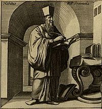 Michal Piotr Boym
was born in Lwów in Poland in 1612 and went to China as a Jesuit missionary in 1643, having entered the Order in Poland in 1629. In China, Boym was outstandingly successful as a missionary scientist and so emphatically secured the confidence of the Chinese that the Ming Pretender Yongli (Southern Ming Dynasty) appointed him Chinese ambassador to Venice and Rome between 1652 and 1656. The Zhu Youlang's court (Yongli) entrusted the Jesuit to bring letters from himself and the Empress Dowager to the Pope, the Doge of Venice, and the King of Portugal.
These letters were primarily requests for military aid against the Manchus.
Boym's mission was exceptionally difficult and dangerous because the Venetians and Portuguese were both inclined to abandon the seemingly hopeless Ming loyalist cause and concentrate on developing trade relations with the victorious Manchus.
Even the leaders of the Jesuit Order disapproved of getting involved in the Ming-Qing conflict.
Boym had to wait until 1655, when the new pope Alexander VII was elected, to get a positive response from the Vatican. Even then, the pope offered no practical support, only a letter expressing sympathy and blessing for the Ming loyalist court. With this letter, Boym could secure a promise of military aid from the Portuguese king, but again it was only a promise without any practical action taken.
Nonetheless, Boym began his return journey to China and reached Vietnam (then known as Dai Viet) in 1658. He then tried to reach Zhu Youlang's court in Yunnan by traveling through Guangxi, but died en route in 1659.
Yongli was sympathetic to Roman Catholicism and did not object to the baptism of his heir apparent, the Empress Dowager, the Empress, and his biological mother by the Jesuit Andreas Xavier Koffler
Consulted reference works
- Chabrié, R, « Michel Boym : Jésuite polonais et la fin des Ming en Chine (1646-1662) », (Paris,1933), pp. 229, 256.
- Fuchs, Walter, “A Note on Father M. Boym’s Atlas of China”, Imago Mundi, Vol. 9 (1952), pp. 71-72”.
- Szczesniak, Boleslaw, “The Mappa Imperii Sinarum of Michael Boym”, Imago Mundi, Vol. 19 (1965), pp. 113-115.
- Szczesniak, Boleslaw, “The Atlas and Geographic Description of China: A Manuscript of Michael Boym (1612-1659)”, Journal of the American Oriental Society, Volume 73, 1953.
- Lin Hong 林宏. “Atlases of China by the Jesuits Ruggieri, Boym and Martini”. Faculty Member, Department of History, School of Humanities, Shanghai Normal University
- Sotheby's, London, 22nd November 1988. “The Library of Philip Robinson; Part II, The Chinese Collection”.
Auction on August 19 2023 at VICHY ENCHERES
VICHY ENCHERES - 16, avenue de Lyon 03200 Vichy, France
Contact: +33 (0)4 70 30 11 20 - +33 (0)4 70 30 11 29 - email: vente@vichy-encheres.com
Expert for the following lot: Béatrice Loeb-Larocque. Tel. +33 (0)6 11803375- info@loeb-larocque.com
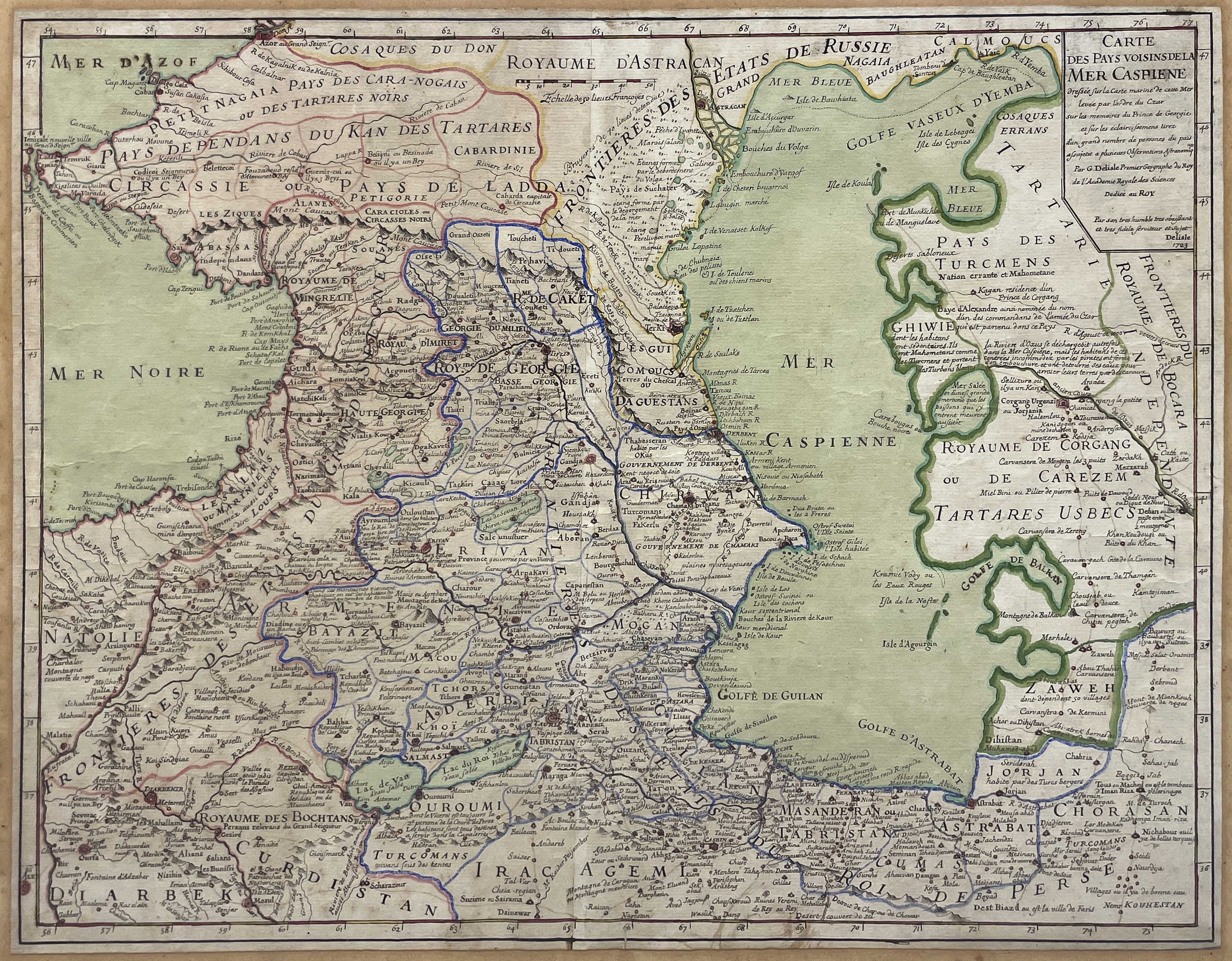
MANUSCRIPT MAP OF THE CASPIAN SEA ATTRIBUTED TO G. DELISLE

DELISLE, G. Carte des Pays Voisins de la Mer Caspiene, dressée sur la carte marine de cette Mer levée par l’ordre du Czar sur les mémoires du Prince de Géorgie et sur les éclaicissemens tirez d’un grand nombre de personnes du païs assujetie à plusieurs Observations Astronomiques. Par G Delisle Premier Geographe du Roy de l’Academie Royale des Sciences / Dediée au Roy / Par son tres humble tres obeissant et tres fidele serviteur et sujet / Delisle 1723.
(Paris), G. Delisle, 1723
450 x 600 mm.
Estimation 1 500/3 000 €
A highly detailed manuscript map extending from the Sea of Azov to the turquoise mines of northern Iran, including Georgia, Azerbaijan and Armenia. It depicts roads, forts, cities, and villages, and the topography is filled with notations. This map can be attributed to Guillaume Delisle, although it differs in some respects from the engraved map published in 1723. The title and cartouche differ from the published map.
The title, apart from the Prince of Georgia, does not mention other sources and the cartouche is more sober. The map does not include compass roses, not all mountains are shown, and geographical names are sometimes spelled differently: "Cath or Kaité", instead of "Kayté" on the engraved map. The manuscript map has only one scale: "Scale of 50 French Leagues", while the engraved map has three: "Wurst or Mils of Russia from 100 to the degree / Farsangues or Leagues of Persia from 18 1/3 to the degree / Common Leagues of France from 25 to the degree (40). This difference in scale implies that certain regions figured on the edge of the engraved map are not shown on manuscript one (north of the Sea of Azof).
The map is based on information from the Prince of Georgia and from the Czar's ambassadors to the Persian Empire. Roads and trade routes are shown and caravansaries noted; several Kurdish areas are named, some described as Republics. In Kurdistan (Curdistan) there is the "Valley where the Paradise of the Assassins once was". Areas frequented by nomads are indicated as well as those of "sedentaires." Villages with good water are identified.
A note regarding the Tomb of Iman Riza says it is a great place of pilgrimages.
Auction on August 19 2023 at VICHY ENCHERES
Expert for the above lots: Béatrice Loeb-Larocque. Tel. +33 (0)6 11803375- info@loeb-larocque.com