
Auction with Portulan chart
Lot N° 1.
PLACIDO CALOIRO et OLIVA [workshop].
[Portulan cahrt on vellum of the Mediterranean]. Messine, between 1621 and 1665.
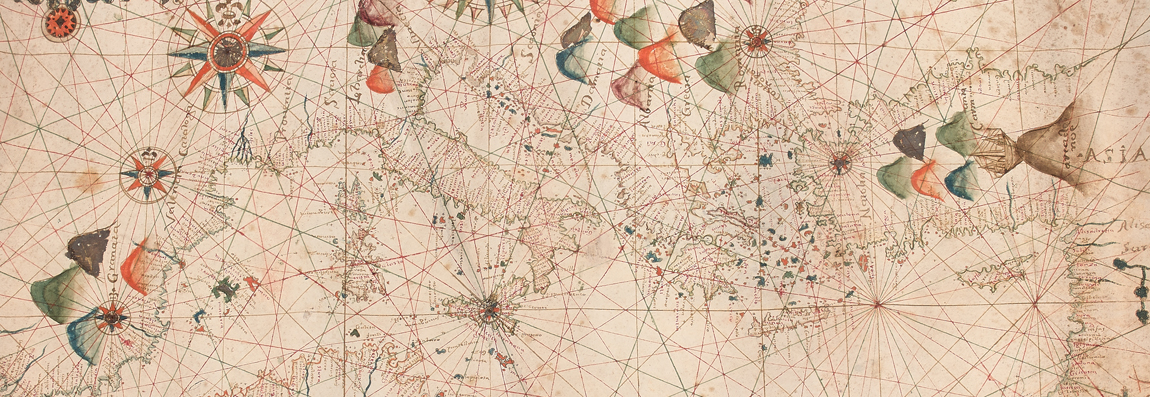
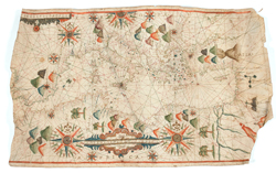
Manuscript sea chart pen and ink drawn on vellum measuring 71.5 x 44.5 cm. elaborately decorated in the traditional style of portolan charts. In very good condition except for two sections where the vellum is missing. On the western edge, a strip about 30 cm wide has been lost and in the southeast a small section of the corner has been torn away. Despite these losses, the actual coverage area of the chart has not been significantly impacted.
With a career spanning some four decades, some significant variation is to be expected. Nonetheless, an attribution to the workshop of Placido Caloiro et Oliva is fully justified and an attribution to Placido himself is credible. This would put the date of production somewhere between 1621 and 1665.
SOLD FOR Euros 22.000
Analysis of a Portolan Chart of the 17th century
Richard Pflederer (January 21, 2019)
Cartographically, the chart is very typical for charts of the mid-17th century,
including the extent of the coverage area, and the minimal depiction of details
within the land masses. For centuries preceding the production of this chart most
charts exhibited the distinctive counterclockwise rotation of about 9°, presumably
related to the magnetic declination in the Mediterranean. Although by the mid-17th
century some cartographers were recognizing this discrepancy and drawing charts to
true geographical directions, the chart maker of this chart chose to follow the
traditional pattern, and thus the rotation is observed. The center of the hidden
circle from which the 32 primary rhumb lines radiate is located in Sicily.
Decorative elements
The chart is heavily decorated with most of the interior of landmasses covered by
decorative devices. There are two large compass roses as well as a large half compass
rose and several smaller ones. But the element which dominates the interior of North
Africa is an elaborately embellished scale bar about 22 cm long. Next in importance
are the numerous schematically represented mountains, and also several palm trees in
Africa. In the Levante there are depictions of three specific locations: the Monastery
of St. Catherine, Mount Calvary with three crosses and the River Jordan. But possibly
the most unusual is found in Anatolia: Noah’s Arc resting atop Mt. Ararat.
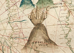 A detail showing Noah’s Arc resting on the top of Mount Ararat in Anatolia. This is a
very unusual drawing whose Old Testament reference complements the New Testament
depiction of Mount Calvary with its three crosses in Palestine.
A detail showing Noah’s Arc resting on the top of Mount Ararat in Anatolia. This is a
very unusual drawing whose Old Testament reference complements the New Testament
depiction of Mount Calvary with its three crosses in Palestine.
Cartographic considerations
By the mid-17th century, the cartographic content of Mediterranean Sea charts was
firmly established with very little opportunity or need for continuing evolution.
And this chart is no exception. The shape of the coastlines was well known and the
conventions for depicting navigational hazards established. As noted above the system
of 32 radiating rhumb lines is centered on Sicily, coincidently very near the home
of the author to whom we are attributing the chart.
At each of sixteen points where the radiating lines intersect the hidden circle, a secondary node is formed from which another 32 rhumb lines radiate. At fourteen of these sixteen nodes, the author has placed a compass rose, so the navigator was well equipped with lines from which to plot his course.
One notable anomaly is the treatment of the Black Sea. First, only the southwestern quadrant of the sea is included whereas in most charts of the period, we would expect to see the entire sea. Second, depiction of Crimea is almost schematic rather than the more finely dawn coastlines which were available to cartographers in this period. We can only speculate on the reasons for this treatment, but one possibility is that the chart was produced on commission for a captain whose business was limited to the waters of the Mediterranean and other adjacent seas.
The 9° rotation of the charts versus true geographic directions at first glance might seem to present navigational problems. However, in the period compasses were not corrected for magnetic declination, so ships were typically sailed to magnetic courses which were roughly equal to the directions extracted from the charts. And so, the directional errors in the chart were largely offset by the variation in the compasses.
Authorship
A majority of portolan charts bear an inscription with the author’s name and the date.
No inscription is present on this chart, but there likely was one on the now-missing
western part of the chart. However, after searching for similar charts within the
indicated timeframe, a very strong resemblance to the works of Placido Caloiro et
Oliva was noted. A comparison with five charts known to be the work of this author
revealed excellent correspondence on over twenty different cartographic and decorative
reference points.
The cartographic areas analyzed include depictions of specific
geographical areas such as the Strait of Gibraltar, the islands of Sicily, Cyprus
and Crete as well as the coastline of North Africa. Similarly, for decorative elements,
the large scale bar and compass roses, the palm trees, Mount Calvary and the schematic
River Jordan all match perfectly with the works of Placido Caloiro et Oliva. The form
and shape of the mouths of major rivers such as the Nile and the Rhone also match the
charts of Caloiro et Oliva.
However, some differences are noted. Most of the charts known to be drawn by Caloiro et
Oliva have as many as 20 town vignettes while the present chart has none. Others signed
by this author have images of soldiers and animals while this chart has none. Finally,
the drawing of the coastlines and the writing of the placenames on this chart do not
seem to be executed as precisely on some of his other charts. However, with a career
spanning some four decades, some significant variation is to be expected.
Nonetheless, an attribution to the workshop of Placido Caloiro et Oliva is fully
justified and an attribution to Placido himself is credible. This would put the date
of production somewhere between 1621 and 1665.
A few comments on the Caloiro et Oliva family
This family is apparently a branch of the Oliva family which includes over a dozen
cartographers who signed charts and atlases between 1538 and 1673. The form of the
surnames varied over the decades and centuries, particularly depending on where the
business was located at the time. We see ‘Oliva’, ‘Ollive’, ‘Ollives’, ‘Olivo’ as
well as ‘Caloiro et Oliva’. Three members of the Caloiro et Oliva branch of the
family signed charts between 1621 and 1673, but with the majority of these (32 items)
were signed by Placido between 1621 and 1665. There are also another five charts/atlases
attributed to him. It is interesting that while many of the Oliva family moved between
eight different ports ranging from Messina to Barcelona to Venice, all of Placido’s
works are signed in Messina.
 About the author
Richard Pflederer is a noted researcher in the History of Cartography whose recent
focus has been portolan chart and atlases. These are manuscript sea charts which were drawn
on vellum for over four hundred years beginning at the end of the 13th century.
His latest project, Finding their Way at Sea (release date October 2012) is a richly
illustrated book intended for a general audience. It tells the story of portolan charts
from a human point of view, focusing on the cartographers who drew the charts, the mariners
who sailed by them and their destinations in the Med Sea and around the world.
He is the author of five detailed catalogues of major collections in the US and England,
including the British Library (London), the Bodleian Library (Oxford), the National
Maritime Museum (Greenwich), the Huntington Library (San Marino) and the Newberry Library
(Chicago). In addition to these catalogues he is the author of a definitive and
comprehensive census of all known surviving charts and atlases.
He also lectures extensively on this and other cartographic subjects at international
venues including Verona, London, Greenwich, Vienna, Guatemala City, Washington and Chicago.
He is a Fellow of the Royal Geographical Society, a member of the International Map
Collectors Society, the Editorial Advisory Board of the Journal of the Washington Map
Society and the Society for the History of Discoveries. In 2010 he founded the
Williamsburg Map Circle. He is a lecturer at the Christopher Wren Association of
the College of William & Mary, and a member of the adjunct faculty of Old Dominion
University.
He and his wife, Sue, share their time between Williamsburg, Virginia and Montepulciano, Tuscany.