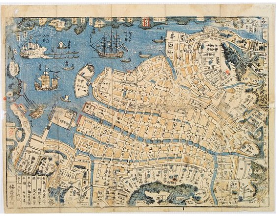
BAIKO-DO. - Shinkan Nagasaki no Dzu.
Description
The map shows much activity of the foreign ships. In the bay are anchored Dutch ships and Chinese Junks. One Dutch ship, undertowed by lines of tugboats, is firing its cannons in greeting.
Throughout the Edo period, Nagasaki, along with Kyoto, Osaka and Edo was the scene of a flourishing publishing business in woodblock prints. Maps of Nagasaki were first published in the 1670s and from the 1770s on, they came out in a constant stream.
Due to the Dutch presence in Nagasaki, Japan learned many aspects of the scientific and technological revolution occurring in Europe at that time, helping the country build up the beginnings of a theoretical and technical scientific base, which helps to explain Japan's success in its radical and speedy modernization following the opening of the country to foreign trade in 1854.
With its original cover, including distance tables to main places from Nagasaki.
Upper part from right to left: Kyoto 210ri, Edo 332ri, Osaka 197ri, Shimonosek 59ri,Bungo Hita 46ri, Higo-Kumamoto 39ri, Satsuma-Kagoshima 65ri, Hiuga-Satohara 71ri. Lower part: Hizen-Saga 29ri, Chikuzen-Fukuoka 50ri, Hirado 32ri, Karatsu 32ri, Kurume 36ri, Yanagawa 32ri, Shimabara 16ri and Omura 10ri. 1ri = 4km.
- Reference N°: 01018
Some of the most asked FAQ by our clients
The Librairie was founded in 1958 by Louis Loeb-Larocque. Originally, he arrived in France from Germany shortly after World War II. He started an antiquarian map and book shop in Paris, specializing in early maps, atlases, travel books, and prints. The shop was located at Rue Le Peletier until 1996, and was frequently visited by collectors and fellow dealers from all parts of the world.
At present, the office is located at 31 rue de Tolbiac in Paris in the lively 13th district, a 5-minute walk from the Bibliothéque Nationale de France (Metro Line 14).
We welcome visitors to our shop by appointment, Monday through Friday.
MORE ABOUT LOEB-LAROCQUE
Browse the catalog now >>>
- "Original colors / col. ancien-d' époque" means that the item was colored at or about the time of publication.
- "Colored/color" means that the map has recently been hand-colored within the last 50 years.
Measurements are given in centimeters; height is given first, excluding margins. Size is mentioned of the plate mark; height is given first. When there is no plate mark, we take the sizes of the illustration. In some instances, we additionally mention the size of the sheet in the condition field.
The date and place mentioned in our catalog is the date when the item was made and published. Where the publishing date is approximate, then c. (circa) is used.
We do not sell reproductions!
Browse the catalog now >>>
DO A VALUATION >>>
Others have remained steadily desirable without seeing a significant rise in price, and still others can be purchased for little money but give great personal satisfaction.
Librairie Loeb-Larocque, with 60 years of experience in the rare map and book trade, can help you decide what kind of collection you would like to build.
If you want to sell books and maps, contact us for a free estimate. Send us photos by email, or make an appointment for a physical examination of the object. We will then make a purchase offer.
DO A FREE APPRAISAL >>>
The cancellation period will expire 14 calendar days from the day after the date on which you or a third party (other than the carrier and indicated by you) acquires physical possession of the lot.
To exercise the right to cancel, you must inform Joppen et Loeb Associates SARL, which is offering to sell the lot either as an agent for the seller or as the owner of the lot, of your decision to cancel this contract by a clear statement (e.g. a letter sent by post, 31 rue de Tolbiac, 75013 Paris France or e-mail (info @ loeb-larocque.com).
Browse the catalog now >>>
- We charge a flat shipping fee of 15 euros for shipments within France for shipments up to one kg.
- For parcels shipped within Europe, a flat 25,00 euros is charged.
-For shipments outside of Europe, the postal fee is 25.00 euros for the USA and Asia
- 45.00 euros for Africa and Australia for parcels up to one kg. Heavier parcels are shipped at a nominal postal fee.
Items are fully insured and usually shipped the day following payment. We ship maps and prints in sturdy tubes or strong packaging if necessary.
The items are shipped when your payment is received.
Browse the catalog now >>>
CONTACT US