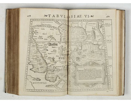
STRABO. - Strabonis nobilissimi et doctissimi philosophi ac geographi Rervm geographicarum commentarij libris XVII contenti, Latini facti Gvilielmo Xylandro Augustano interprete. . .
 Click on image to zoom

Out Of Stock
STRABO. - Strabonis nobilissimi et doctissimi philosophi ac geographi Rervm geographicarum commentarij libris XVII contenti, Latini facti Gvilielmo Xylandro Augustano interprete. . .
Published: Basle, Henri Petri, 1571
Size: 301 x 205mm.
Color: Uncoloured.
Condition: Small in-folio, [116] – 563 – [1] pp., complete (collation : [Latin Cross]6, *****6, [Latin Cross]-[4 Latin Crosses]6, [5 Latin Crosses] 6, a-f6, g8, h-i6, k8, l-m6, n4, o6, p-q4, r-t2, u8, x-z6, A4, B-E6, F-G4, H-K2, L-N4, O-V6, X8, Y-Z4, Aa2, Bb-Cc4, Dd2, Ee6, Ff-Gg2, Hh-Ii6, Kk4, Ll2, Mm4), Roman and Italic type, catchwords, printer’s device (title and last leaf), wood engravings, engraved headpieces and ornamental letters, 27 large maps (double-page) and 6 smaller maps in text, one diagram in text. Bound in full tan morocco, boards and spine gilt, arms at the center of boards (see Provenance below), gilt edges (restorations to the binding and to paper, including title page). Dimensions: 301 x 205 mm.
Description
A few marginal annotations (pp. 109-111), in a 19th c. hand. Latin translation with a commentary by Wilhelm Holtzmann, also called Guglielmus Xylander. (1532-1576), librarian and professor of Greek at Heidelberg. An active Greek scholar, Holtzmann also supplied Latin translations of a number of authors including Tryphiodorus (Basel, 1548), Dio Cassius (Basel, 1558), Marcus Aurelius (1559), Plutarch (Basel, 1561-1570). There is another edition of the present Strabo translation with the facing Greek published the same year (Adams, S-1907 - Graesse, VI, 505). This edition of Strabo contains 27 large maps (double page) and 6 smaller maps incorporated in the text (Euboea, Crete, Lesbos, Rhodes, Cyprus and Cephalonia). The large maps are engraved after models found in Ptolomy’s Geographia as established by Sebastien Münster (Basel, Henri Petri, 1540; see Phillips, 1914, 3388).
Ptolomy’s Geographia contained 48 maps and the work had a considerable influence (24 editions in 100 years).
In 1544, Münster’s work entitled Cosmographia supplied additional information on cities, historical figures and local traditions and costumes (see M. McLean, The Cosmographia of Sebastian Münster: Describing the World in the Reformation, 2007). On Henricus Petri (1508-1579), printer in Basel, see Heckethorn, C.W. The Printers of Basel in the XVth - XVIth centuries, 1897, p. 154.
The first edition of Strabo’s Geography in the original Greek was published in Venice, Aldus, 1516. The first Latin translation was that of Guarino Veronese and Gregorio Tifernate in 1469 (Rome, Sweynheym and Pannartz, [1469]).
The present imprint (1571) is the first to give the corrected Latin translation of Wilhelm Holzmann or Guilielmus Xylander.
PROVENANCE : 1. Du Bellay, Martin (1571-1637), prince d’Yvetot and seigneur of Gizeux, with his gilt arms on the covers of the binding (D’argent, à la bande de fusées de gueules, accompagnées de six fleurs de lis d’azur, rangées en orle). The Du Bellay family was an important noble family from Anjou, whose name comes from the fiefdom called “Bellay-en-Allonnes”, located north-east of Saumur. On Martin du Bellay, see Belleuvre, Paul, « La famille du Bellay », in Revue de l’Anjou et de Maine et Loire, Angers, 1856, pp. 85-86. On the princes of Yvetot, see Bercé, Y.-M. "Le royaume d’Yvetot", in Mélanges offerts au professeur Maurice Gresset : des institutions et des hommes, 2008, pp. 32-37.
His son, Alexandre-Jacques-Laurent Anisson-Dupéron (1776-1852), was « préfet » during the Empire and appointed again head of the Imprimerie royale in 1814 ; he did a lot to save important typographical collections.
References : VD 16, S-9348; Adams, S-1907 ; Phillips, A List of Geographical Atlases in the Library of Congress, Washington, 1914, vol. III, 3390, pp. 78-79; Birachi et al. (dir.), Strabone. Saggio di Bibliografia 1469-1978, Perugia, 1981, p. 37; Kristeller, P.O. Catalogus translationum, pp. 230-231. Not in BM STC German, 1455-1600.
0€
- Reference N°: 44856
