Menu
Menu
Your Cart

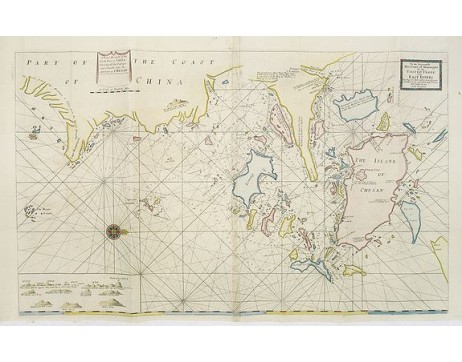
THORNTON, J. - A large draught of the North part of CHINA. Shewing all the passages and chanells into the harbour of CHUSAN. / To the honourable the court of mannagers for the UNITED TRADE to the EAST INDIES.
THORNTON, J. -  A large draught of the North part of CHINA. Shewing all the passages and chanells into the harbour of CHUSAN. / To the honourable the court of mannagers for the UNITED TRADE to the EAST INDIES.
THORNTON, J. - A large draught of the North part of CHINA. Shewing all the passages and chanells into the harbour of CHUSAN. / To the honourable the court of mannagers for the UNITED TRADE to the EAST INDIES.
Published: London, William Mount & Thomas Page, 1734
Size: 518 x 865mm.
Color: Coloured.
Condition: In very good condition.

Description

A very fine sea chart of China's Zhejiang Province, from the celebrated Third Book of 'The English Pilot'
This elegant and large chart captures China's modern day Zhejiang province. Located on the East China sea, just below the Yangtze Delta with Shanghai, this region was of major interest to European traders during the eighteenth-century. It features the major port of Zhousan (Chusan), and was the location of the entrance of the Grand Canal of China. The canal, construction of which began in the 5th-century B.C., was then the oldest and longest man-made waterway in the world, which allowed barges to travel hundreds to Beijing.
In 1671, the London cartographer John Seller (fl.1664-97) commenced work on The English Pilot, a work that intended to challenge Dutch hegemony in the sea atlas market. Intended to be published in four books covering different regions of the globe, Seller published an uncompleted book on 'Oriental navigation' in 1675. Unable to continue this Herculean endeavour, Seller sold his rights to John Thornton, the official hydrographer to the English East India Company. Thornton took up the project with great fervour, publishing his first editions in 1689. Thornton did not publish his first edition of the Third Book, detailing navigation in the East Indies, until 1703. While Thornton largely based his charts on those of earlier Dutch cartographers, most notably those found in Pieter Goos' Zee-Spiegel and Lucas Janz Waghenaer's Mariner's Mirror, The English Pilot proved to be enormously popular. When John Thornton died in 1708, his brother Samuel took over the business and added to and modified existing charts. All four books were produced in editions until the 1760s, the Third Book ran into twelve editions up to 1761.
The project succeeded in giving the English dominance in the sea chart market as the eighteenth-century progressed. John Thornton collaborated with Seller in many of his publications but was also an hydrographer in his own right. Thornton was a skilled engraver and played an important part in the production of the various edition's of Seller's Atlas Maritimus, and later issued his own version.
2,500€
  • Reference N°: 31147

Some of the most asked FAQ by our clients

Librairie Loeb-Larocque specializes in maps, atlases, and travel books from the 16th to 19th centuries.
The Librairie was founded in 1958 by Louis Loeb-Larocque. Originally, he arrived in France from Germany shortly after World War II. He started an antiquarian map and book shop in Paris, specializing in early maps, atlases, travel books, and prints. The shop was located at Rue Le Peletier until 1996, and was frequently visited by collectors and fellow dealers from all parts of the world.
At present, the office is located at 31 rue de Tolbiac in Paris in the lively 13th district, a 5-minute walk from the Bibliothéque Nationale de France (Metro Line 14).
We welcome visitors to our shop by appointment, Monday through Friday.

MORE ABOUT LOEB-LAROCQUE
Librairie Loeb-Larocque sells authentic maps, prints, atlases, and rare books. We guarantee the authenticity and condition of each lot listed in our catalogs.
Browse the catalog now >>>
We supply a certificate for each item sold. Librairie Loeb-Larocque fully guarantees the authenticity and condition of each lot described in our catalogs. The warranty is unlimited in time. Defects in lots offered for sale have been carefully noted.
The value of a rare book, atlas, globe, print, or map depends on rarity, condition, binding, provenance, and the significance of any inscriptions it may contain. Béatrice Loeb-Larcque, an expert and member of the Syndicat Français des Experts Professionnels en Œuvres d'Art et Objets de Collection, provides a free appraisal if you are considering selling. We provide auction estimates from photographs sent via the Internet. These estimates are not for valuation purposes and are subject to revision upon inspection of the object. It is impossible to provide verbal estimates over the phone, nor can we respond to requests without a photo.

DO A VALUATION >>>
There is no easy answer to this question. Some books or maps have, without question, appreciated considerably in value over the years.
Others have remained steadily desirable without seeing a significant rise in price, and still others can be purchased for little money but give great personal satisfaction.
Librairie Loeb-Larocque, with 60 years of experience in the rare map and book trade, can help you decide what kind of collection you would like to build.
We buy antiquarian books in our areas of specialization: Atlases, old maps, travel books, and illustrated books.
If you want to sell books and maps, contact us for a free estimate. Send us photos by email, or make an appointment for a physical examination of the object. We will then make a purchase offer.

DO A FREE APPRAISAL >>>
Visitors are welcome to our shop by appointment, Monday through Friday from 9 AM to 7 PM. We participate in fairs in Amsterdam, London, Venice, and often travel to find interesting items. Registered users receive monthly email updates. Follow us on Instagram or Facebook.
CONTACT US