Menu
Menu
Your Cart

WYLDT, J. - Map of the Countries lying between Turkey & Birmah, Comprising Asia Minor, Persia, India, Egypt & Arabia, and including the Black, Caspian & Red Seas . . . . 1841
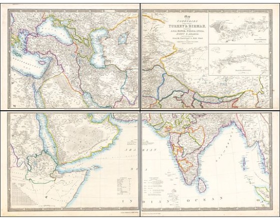
WYLDT, J. -  Map of the Countries lying between Turkey & Birmah, Comprising Asia Minor, Persia, India, Egypt & Arabia, and including the Black, Caspian & Red Seas . . . . 1841
WYLDT, J. - Map of the Countries lying between Turkey & Birmah, Comprising Asia Minor, Persia, India, Egypt & Arabia, and including the Black, Caspian & Red Seas . . . . 1841
Published: London, 1841
Size: 812 x 1045mm.
Color: Original outline colors.
Condition: Folding map in 4 sheets. If joined 812x1045 (32x41.5 inch)

Description

This striking 4-sheet map, dating to the first half of the 19th century, covers a vast region stretching from Cyprus to Bhutan on the upper sheets and from Egypt to Thailand on the lower sheets. Large insets of the Bosphorus and the Dardanelles highlight two key maritime passages, underscoring their importance as gateways between Europe and Asia, particularly vital for trade and military strategy during this period.

The treatment of the Emirate regions is particularly noteworthy, with an unsually large number of place names in the "Lahsa or Hadjar", along with over two dozen names in the UAE region, including Sharja, Debai, Abouthubbee and Oman or Sahar.
At the bottom of the map, a table provides information on monsoon patterns, or "Periodical Winds," critical for navigation in the Indian Ocean and the Red Sea, which facilitated trade across these waters. Another table outlines distances between major ports in sailing days, an essential resource for merchants and sailors journeying between Europe, the Middle East, India, and beyond. These navigational aids, alongside the map’s detailed geographic and political representation, offer insights into the significance of maritime routes and monsoon knowledge for 19th-century traders and imperial administrators.

Historically, the early 19th century was a period of significant transformation in this region. The Ottoman Empire controlled much of the eastern Mediterranean, including modern-day Turkey, Syria, and Egypt, though its power was waning, and European powers like Britain and France were beginning to exert influence. The British East India Company had stablished a firm hold over the Indian subcontinent, setting up administrative and trade networks that would later form the foundation of the British Raj. In the Arabian Peninsula, local rulers balanced between traditional tribal structures and the growing influence of foreign powers, especially in strategic ports along the Red Sea and Persian Gulf.

This map reflects the geopolitical importance of the region as a crossroad of trade, empire, and culture, with European colonial powers expanding their reach while indigenous empires like the Ottomans struggled to maintain control.
1,100€
  • See other items by this publisher: WYLD, J.
  • Reference N°: 49093

Some of the most asked FAQ by our clients

Librairie Loeb-Larocque specializes in maps, atlases, and travel books from the 16th to 19th centuries.
The Librairie was founded in 1958 by Louis Loeb-Larocque. Originally, he arrived in France from Germany shortly after World War II. He started an antiquarian map and book shop in Paris, specializing in early maps, atlases, travel books, and prints. The shop was located at Rue Le Peletier until 1996, and was frequently visited by collectors and fellow dealers from all parts of the world.
At present, the office is located at 31 rue de Tolbiac in Paris in the lively 13th district, a 5-minute walk from the Bibliothéque Nationale de France (Metro Line 14).
We welcome visitors to our shop by appointment, Monday through Friday.

MORE ABOUT LOEB-LAROCQUE
Librairie Loeb-Larocque sells authentic maps, prints, atlases, and rare books. We guarantee the authenticity and condition of each lot listed in our catalogs.
Browse the catalog now >>>
We supply a certificate for each item sold. Librairie Loeb-Larocque fully guarantees the authenticity and condition of each lot described in our catalogs. The warranty is unlimited in time. Defects in lots offered for sale have been carefully noted.
The value of a rare book, atlas, globe, print, or map depends on rarity, condition, binding, provenance, and the significance of any inscriptions it may contain. Béatrice Loeb-Larcque, an expert and member of the Syndicat Français des Experts Professionnels en Œuvres d'Art et Objets de Collection, provides a free appraisal if you are considering selling. We provide auction estimates from photographs sent via the Internet. These estimates are not for valuation purposes and are subject to revision upon inspection of the object. It is impossible to provide verbal estimates over the phone, nor can we respond to requests without a photo.

DO A VALUATION >>>
There is no easy answer to this question. Some books or maps have, without question, appreciated considerably in value over the years.
Others have remained steadily desirable without seeing a significant rise in price, and still others can be purchased for little money but give great personal satisfaction.
Librairie Loeb-Larocque, with 60 years of experience in the rare map and book trade, can help you decide what kind of collection you would like to build.
We buy antiquarian books in our areas of specialization: Atlases, old maps, travel books, and illustrated books.
If you want to sell books and maps, contact us for a free estimate. Send us photos by email, or make an appointment for a physical examination of the object. We will then make a purchase offer.

DO A FREE APPRAISAL >>>
Visitors are welcome to our shop by appointment, Monday through Friday from 9 AM to 7 PM. We participate in fairs in Amsterdam, London, Venice, and often travel to find interesting items. Registered users receive monthly email updates. Follow us on Instagram or Facebook.
CONTACT US