Menu
Menu
Your Cart

BLAEU, W. - Nova Belgica et Anglia Nova.
BLAEU, W. -  Nova Belgica et Anglia Nova.
BLAEU, W. - Nova Belgica et Anglia Nova.
Published: Amsterdam, 1638
Size: 388 x 505 mm.
Color: In attractive strong original colours.
Condition: Fine condition. Printed on heavy paper. Very good and dark impression. Dutch text on verso. Center fold reinforced.

Description

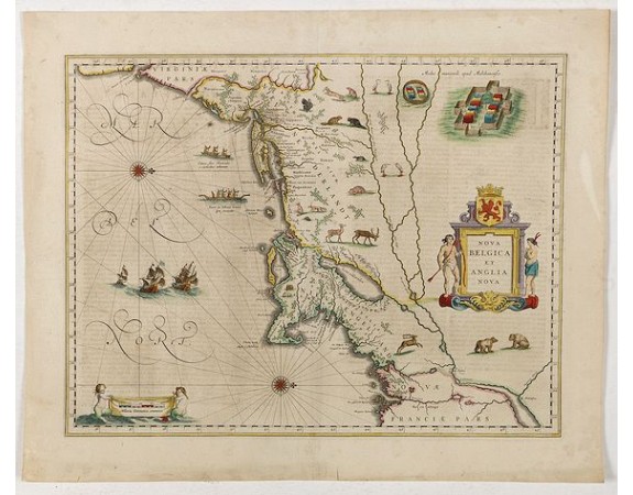
Orientated with north to the right. This is one of the earliest maps to concentrate solely on this area of the colonies, excluding Virginia and the extreme north east coastline of the States.
This would appear to be the first map to include scenes of Indian natives paddling their canoes and also has scenes of Indian villages and habitations, European vessels, animals and birds on each side of the title cartouche.
Lake Champlain, as usual in this period, is shown too far to the east.
The coastal strip is well detailed with settlement names, testifying to the Dutch and English interest in the area, but the map is, above all, a fine example of the superb design and craftsmanship employed by the Blaeu's in their work.
Based on the manuscript survey by Adrian Block, completed about the year 1614.

As Willem Blaeu died in 1638 most of his maps are actually published by his son Joan. This maps carries his (engraved) signature and was actually published in volume II of a French edition of his "Le Theatre du Monde ou Nouvel Atlas", dated 1638, therefore published the last year of his life.
From early on Willem Jansz. Blaeu aimed of publishing an atlas to compete with the Hondius-Jansson Atlas. By 1630, he had published at least 17 folio size maps. Blaeu was able to realize his plan soon after he had acquired the copper plates of the atlas maps by Jodocus Hondius. The "Appendix followed in 1630.
In 1635 he finally realized a "international edition" of a world atlas, the "Theatrum Orbis Terrarum".
This example is from a very rare 1638 French text edition, which has the same copperplates as the 1635 edition, however the text on the verso was reset in two text columns. This edition is the last version the great master printed under his patronage.
2,500€
  • See other items by this publisher: Willem Blaeu
  • Reference N°: 43294

Some of the most asked FAQ by our clients

Librairie Loeb-Larocque specializes in maps, atlases, and travel books from the 16th to 19th centuries.
The Librairie was founded in 1958 by Louis Loeb-Larocque. Originally, he arrived in France from Germany shortly after World War II. He started an antiquarian map and book shop in Paris, specializing in early maps, atlases, travel books, and prints. The shop was located at Rue Le Peletier until 1996, and was frequently visited by collectors and fellow dealers from all parts of the world.
At present, the office is located at 31 rue de Tolbiac in Paris in the lively 13th district, a 5-minute walk from the Bibliothéque Nationale de France (Metro Line 14).
We welcome visitors to our shop by appointment, Monday through Friday.

MORE ABOUT LOEB-LAROCQUE
Librairie Loeb-Larocque sells authentic maps, prints, atlases, and rare books. We guarantee the authenticity and condition of each lot listed in our catalogs.
Browse the catalog now >>>
We supply a certificate for each item sold. Librairie Loeb-Larocque fully guarantees the authenticity and condition of each lot described in our catalogs. The warranty is unlimited in time. Defects in lots offered for sale have been carefully noted.
The value of a rare book, atlas, globe, print, or map depends on rarity, condition, binding, provenance, and the significance of any inscriptions it may contain. Béatrice Loeb-Larcque, an expert and member of the Syndicat Français des Experts Professionnels en Œuvres d'Art et Objets de Collection, provides a free appraisal if you are considering selling. We provide auction estimates from photographs sent via the Internet. These estimates are not for valuation purposes and are subject to revision upon inspection of the object. It is impossible to provide verbal estimates over the phone, nor can we respond to requests without a photo.

DO A VALUATION >>>
There is no easy answer to this question. Some books or maps have, without question, appreciated considerably in value over the years.
Others have remained steadily desirable without seeing a significant rise in price, and still others can be purchased for little money but give great personal satisfaction.
Librairie Loeb-Larocque, with 60 years of experience in the rare map and book trade, can help you decide what kind of collection you would like to build.
We buy antiquarian books in our areas of specialization: Atlases, old maps, travel books, and illustrated books.
If you want to sell books and maps, contact us for a free estimate. Send us photos by email, or make an appointment for a physical examination of the object. We will then make a purchase offer.

DO A FREE APPRAISAL >>>
Visitors are welcome to our shop by appointment, Monday through Friday from 9 AM to 7 PM. We participate in fairs in Amsterdam, London, Venice, and often travel to find interesting items. Registered users receive monthly email updates. Follow us on Instagram or Facebook.
CONTACT US